Difference between revisions of "Adolfo III Land"
m (Text replacement - "Creeperian Spanish" to "Creeperian") |
|||
| (9 intermediate revisions by the same user not shown) | |||
| Line 1: | Line 1: | ||
{{short description|Creeperian Tierrasurian territorial claim}} | {{short description|Creeperian Tierrasurian territorial claim}} | ||
{{use dmy dates|date=September 2021}} | {{use dmy dates|date=September 2021}} | ||
| + | {{Good article}} | ||
{{Infobox settlement | {{Infobox settlement | ||
| name = Adolfo III Land | | name = Adolfo III Land | ||
| − | | native_name = Տիերրա դե Ադոլֆո | + | | native_name = Տիերրա դե Ադոլֆո Գ<br />Tierra de Adolfo III |
| official_name = Administrative Territory of Adolfo III Land | | official_name = Administrative Territory of Adolfo III Land | ||
| settlement_type = [[Tierrasur#Tierrasurian territorial claims|Tierrasurian territorial claim]] | | settlement_type = [[Tierrasur#Tierrasurian territorial claims|Tierrasurian territorial claim]] | ||
| Line 82: | Line 83: | ||
}} | }} | ||
| − | '''Adolfo III Land''' ([[ | + | '''Adolfo III Land''' ([[Creeperian language|Creeperian]] – [[Creeperian script|Creeperian]]: Տիերրա դե Ադոլֆո Գ; Creeperian – [[Iberic script|Iberic]]: ''Tierra de Adolfo III''; <small>Creeperian pronunciation:</small> {{color|#122080|[ˈtie.ra de aˈdol.fol teɾˈce.ɾo]}}), officially known as the '''Administrative Territory of Adolfo III Land''' (Creeperian – Creeperian: Տերրիտորիո Ադմինիստրատիվո դել Տիերրա դե Ադոլֆո Գ; Creeperian – Iberic: ''Territorio Administrativo del Tierra de Adolfo III''), and also known as the '''Creeperian Tierrasurian Territory''' (Creeperian – Creeperian: Տերրիտորիո Տիերրասփրեթո Ծրեեպերիանո; Creeperian – Iberic: ''Territorio Tierrasureño Creeperiano''), is the territory in [[Tierrasur]] claimed by [[Creeperopolis]]. The territorial claim is named after [[Adolfo III of Creeperopolis|Adolfo III]], who was reigning as [[Monarchy of Creeperopolis|Emperor of Creeperopolis]] at the time Tierrasur was discovered. |
The Creeperian claim covers the geographic area known as Adolfo III Land, which was named after the initial Creeperian claim. Despite unofficially claiming the entirety of Tierrasur, the Creeperian territorial claim's official boundaries were defined on 1 December 1931 by the ''Decree of Adolfo III Land in Tierrasur'' by the ministries of [[Ministry of Internal Affairs of Creeperopolis|Internal Affairs]] and [[Ministry of Defense of Creeperopolis|Defense]]. The official claim states: | The Creeperian claim covers the geographic area known as Adolfo III Land, which was named after the initial Creeperian claim. Despite unofficially claiming the entirety of Tierrasur, the Creeperian territorial claim's official boundaries were defined on 1 December 1931 by the ''Decree of Adolfo III Land in Tierrasur'' by the ministries of [[Ministry of Internal Affairs of Creeperopolis|Internal Affairs]] and [[Ministry of Defense of Creeperopolis|Defense]]. The official claim states: | ||
| Line 106: | Line 107: | ||
On 20 December 1838, [[Creeperopolis]] began its [[Creeperian conquest of Rakeo|conquest]] of [[First Republic of Rakeo|Rakeo]] under Chief Admiral [[Jorge Montt Álvarez]]. Just before the conquest began, Montt Álvarez put Admiral [[Agustín Prat Chacón]], his first cousin, in charge of setting an expedition south in an effort to find a more direct and quicker route to the [[San Carlos Islands]]. Previous Creeperian admirals had theorized of such a route existing, however, their ships were unable to bear the rough waters of the [[Southern Ocean]] and had to abandon all efforts for a direct route south. With improved ships of the 19th century, the Creeperans were confident in the ability of their ships to traverse the waters of the Southern Ocean. | On 20 December 1838, [[Creeperopolis]] began its [[Creeperian conquest of Rakeo|conquest]] of [[First Republic of Rakeo|Rakeo]] under Chief Admiral [[Jorge Montt Álvarez]]. Just before the conquest began, Montt Álvarez put Admiral [[Agustín Prat Chacón]], his first cousin, in charge of setting an expedition south in an effort to find a more direct and quicker route to the [[San Carlos Islands]]. Previous Creeperian admirals had theorized of such a route existing, however, their ships were unable to bear the rough waters of the [[Southern Ocean]] and had to abandon all efforts for a direct route south. With improved ships of the 19th century, the Creeperans were confident in the ability of their ships to traverse the waters of the Southern Ocean. | ||
| − | Prat Chacón's expedition left [[San Pedro, San Pedro|San Pedro]] in mid-December 1838 with the primary objective of finding such a direct route, but also to inform Creeperian naval units in the San Carlos Islands about the upcoming conquest of Rakeo. As the expedition headed further south, they began to notice a considerable drop in temperature, and on 6 January | + | Prat Chacón's expedition left [[San Pedro, San Pedro|San Pedro]] in mid-December 1838 with the primary objective of finding such a direct route, but also to inform Creeperian naval units in the San Carlos Islands about the upcoming conquest of Rakeo. As the expedition headed further south, they began to notice a considerable drop in temperature, and on 6 January 1839, Prat Chacón unexpectedly discovered a large landmass which he described as an "island of ice." He named the landmass ''Isla de Adolfo III'' in the name of Emperor [[Adolfo III of Creeperopolis|Adolfo III]]. His expedition attempted to go around the landmass, but they quickly found out that the landmass was much larger than originally believed. |
[[File:General Porfirio Díaz.JPG|left|thumb|200px|Emperor [[Adolfo III of Creeperopolis|Adolfo III]] (reign: 1833–1887), the namesake of the claim.]] | [[File:General Porfirio Díaz.JPG|left|thumb|200px|Emperor [[Adolfo III of Creeperopolis|Adolfo III]] (reign: 1833–1887), the namesake of the claim.]] | ||
| Line 194: | Line 195: | ||
Precipitation in Adolfo III land is relatively rare, and the closer to the south pole, the rarer precipitation becomes, making the claim mostly a cold desert in the interior. The coastal areas are mostly a tundra climate receiving more precipitation that the interior of the territory. Most of the coastal areas are covered in permafrost, making plant life effectively impossible. | Precipitation in Adolfo III land is relatively rare, and the closer to the south pole, the rarer precipitation becomes, making the claim mostly a cold desert in the interior. The coastal areas are mostly a tundra climate receiving more precipitation that the interior of the territory. Most of the coastal areas are covered in permafrost, making plant life effectively impossible. | ||
| − | Entirely surrounded by the [[Southern Ocean]] and entirely below latitude 60° south, temperatures in Adolfo III Land are almost always below the freezing point throughout the year. The highest ever recorded temperature was recorded on 14 January 1999 at 55.4°F (13.0°C), while the coldest temperature ever recorded was –19.7°F (–28.7°C) on 1 July 1970. | + | Entirely surrounded by the [[Southern Ocean]] and entirely below latitude 60° south, temperatures in Adolfo III Land are almost always below the freezing point throughout the year. The highest ever recorded temperature was recorded on 14 January 1999 at 55.4°F (13.0°C), while the coldest temperature ever recorded was –19.7°F (–28.7°C) on 1 July 1970. |
== Population == | == Population == | ||
| Line 209: | Line 210: | ||
| post = Administrator | | post = Administrator | ||
| body = Adolfo III Land | | body = Adolfo III Land | ||
| − | | native_name = Ադմինիստրադոր դել Տիերրա դե Ադոլֆո | + | | native_name = Ադմինիստրադոր դել Տիերրա դե Ադոլֆո Գ |
| insignia = File:Coat of Arms of Adolfo III of Creeperopolis.png | | insignia = File:Coat of Arms of Adolfo III of Creeperopolis.png | ||
| flag = File:AT Adolfo III Land Flag.png | | flag = File:AT Adolfo III Land Flag.png | ||
| Line 441: | Line 442: | ||
[[Category:Terraconserva]] | [[Category:Terraconserva]] | ||
[[Category:Tierrasur]] | [[Category:Tierrasur]] | ||
| + | [[Category:WikiProject TRA World Building example articles]] | ||
Latest revision as of 21:24, 12 March 2024
Adolfo III Land Տիերրա դե Ադոլֆո Գ Tierra de Adolfo III | |
|---|---|
| Administrative Territory of Adolfo III Land | |
Clockwise from top left: Watercraft in the Southern Ocean, Penguins jumping into water, Punto Sur at night, dogs at the Agustín Prat Chacón Base. | |
 Flag  Coat of arms | |
| Country | |
| Department | |
| Claimed | 6 January 1839 |
| Claim reaffirmed | 1 December 1931 |
| Founded by | Agustín Prat Chacón |
| Named for | Adolfo III |
| Capital | Punto Sur |
| Government | |
| • Captain General | Diego Holguín Dávila (IC) |
| • Administrator | José Arcos Castañón (Navy) |
| Highest elevation | 10,627 ft (3,239 m) |
| Lowest elevation | 0 ft (0 m) |
| Population (2021) | |
| • Total | 270 |
| Demonym(s) | Tierrasureño Creeperiano |
| Area code(s) | 31 |
| Vehicle registration | S AA-0000-A |
| Research stations | Agustín Prat Chacón Base Gabriel Castillo Luján Base Gonzalo Coronado Alvarado Base |


Adolfo III Land (Creeperian – Creeperian: Տիերրա դե Ադոլֆո Գ; Creeperian – Iberic: Tierra de Adolfo III; Creeperian pronunciation: [ˈtie.ra de aˈdol.fol teɾˈce.ɾo]), officially known as the Administrative Territory of Adolfo III Land (Creeperian – Creeperian: Տերրիտորիո Ադմինիստրատիվո դել Տիերրա դե Ադոլֆո Գ; Creeperian – Iberic: Territorio Administrativo del Tierra de Adolfo III), and also known as the Creeperian Tierrasurian Territory (Creeperian – Creeperian: Տերրիտորիո Տիերրասփրեթո Ծրեեպերիանո; Creeperian – Iberic: Territorio Tierrasureño Creeperiano), is the territory in Tierrasur claimed by Creeperopolis. The territorial claim is named after Adolfo III, who was reigning as Emperor of Creeperopolis at the time Tierrasur was discovered.
The Creeperian claim covers the geographic area known as Adolfo III Land, which was named after the initial Creeperian claim. Despite unofficially claiming the entirety of Tierrasur, the Creeperian territorial claim's official boundaries were defined on 1 December 1931 by the Decree of Adolfo III Land in Tierrasur by the ministries of Internal Affairs and Defense. The official claim states:
The Administrative Territory of Adolfo III Land, otherwise known Adolfo III Land or the Creeperian Tierrasurian Territory, is: all lands, islands, islets, reefs, glaciers (pack-ice), and others, known and unknown, and respective territorial waters, existing within the limits of the cap constituted by the meridians 0° (the prime meridian) and 120° longitude west of Ankarabad.
The territory was founded and claimed by Creeperian Admiral Agustín Prat Chacón on 6 January 1839 when he discovered Tierrasur after an expedition south to find a quicker and more direct route to the San Carlos Islands. Throughout the late-19th and early 20th centuries, Creeperian expeditions ventured into the continent to explore and map the continent. In 1931, Nuevo Creeperópolis I became the first Creeperian base established on Tierrasur, however, it was soon abandoned in 1933 after the outbreak of the Creeperian Civil War.
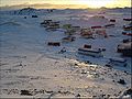
A new base, Nuevo Creeperópolis II, was founded in 1950 after the civil war ended, but it was soon abandoned the following year after it was discovered to have been built on an ice shelf which was expected to detach from the continent, which it did in 1954, losing the base the the Southern Ocean. The Agustín Prat Chacón Base was established in 1952 and remains active to the present day, and since then, two more bases have been opened: the Gabriel Castillo Luján Base in 1966 and the Gonzalo Coronado Alvarado Base in 1980. A permanent settlement, Punto Sur, was also established in 1953 as a civilian settlement to legitimize Creeperopolis' claim to Adolfo III Land.
The territory's capital is Punto Sur and its current Mayor and Administrator is José Arcos Castañón. The territory is legally administered by the department of San Salvador, but it was historically administered by Rakeo until its independence in 1918. Claiming disputes between Creeperopolis and an independent Rakeo persisted until 1962 when Rakeo abandoned all claims to Adolfo III Land following its defeat in the Surian Fishing War.
The highest point in Adolfo III Land is Punto Adolfo III, which its peak is 11,625 pies[note 1] in elevation, and its lowest point is its shore with the Southern Ocean at sea level. Like in the rest of the continent, temperatures are almost always below the freezing point year-round. The Creeperian claim is the largest territorial claim on Tierrasur. The territory covers the timezones AMT 0, –1, –2, –3, –4, –5, –6, and –7, however, only AMT–4 is used as it aligns with the timezone used in San Salvador. Daylight savings time is not observed in the territory, as it is not observed in the rest of Creeperopolis.
As of 2021, a total of 270 people live in Tierrasur during the summer while it is reduced to 250 people during the winter. Punto Sur is the largest settlement and capital city of the territory with 180 people. Most of the people on the continent are either scientists, military, or civilians, with politicians occasionally residing there for short visits. A total of eleven babies have been born in Adolfo III Land, all of whom were born in Tierrasur between 1970 and 2014 in an effort by the Creeperian government to further legitimize their claim to the territory. Tourism is offered by the Creeperian government during the summer months in Punto Sur and the surrounding areas, as well as tours to the Agustín Prat Chacón Base. The primary airport in the territory is the Agustín Prat Chacón Airport in Punto Sur which utilizes a gravel runway. Ice air fields are also present at the three active bases.
Contents
History
19th century

On 20 December 1838, Creeperopolis began its conquest of Rakeo under Chief Admiral Jorge Montt Álvarez. Just before the conquest began, Montt Álvarez put Admiral Agustín Prat Chacón, his first cousin, in charge of setting an expedition south in an effort to find a more direct and quicker route to the San Carlos Islands. Previous Creeperian admirals had theorized of such a route existing, however, their ships were unable to bear the rough waters of the Southern Ocean and had to abandon all efforts for a direct route south. With improved ships of the 19th century, the Creeperans were confident in the ability of their ships to traverse the waters of the Southern Ocean.
Prat Chacón's expedition left San Pedro in mid-December 1838 with the primary objective of finding such a direct route, but also to inform Creeperian naval units in the San Carlos Islands about the upcoming conquest of Rakeo. As the expedition headed further south, they began to notice a considerable drop in temperature, and on 6 January 1839, Prat Chacón unexpectedly discovered a large landmass which he described as an "island of ice." He named the landmass Isla de Adolfo III in the name of Emperor Adolfo III. His expedition attempted to go around the landmass, but they quickly found out that the landmass was much larger than originally believed.

Prat Chacón returned to Creeperopolis to inform Montt Álvarez of the discovery, and in 1843, a new expedition was sent with better clothing and more supplies to attempt a landing on the landmass, which had been renamed to Tierra de Adolfo III. Prat Chacón made the first confirmed landing on the continent of Tierrasur on 20 January 1843. It has been theorized by some historians that Creeperian Admiral Gabriel Castillo Luján may have landed on the continent in 1457 when attempting to achieve the same feat of finding a direct route to the San Carlos Islands in which his fleet subsequently disappeared, however, no evidence of such a supposed landing in the 15th century has been uncovered. Because of the lacking evidence of Castillo Luján's supposed landing, Prat Chacón is currently recognized as the first person to step foot on Tierrasur. During the landing, the flags of Creeperopolis and the Creeperian Navy were planted in the ground. The expedition established a temporary shelter on the landmass before returning to Creeperopolis in early-February 1843.
A new Creeperian expedition numbering 300 men under Admiral Gonzalo Coronado Alvarado landed in Adolfo III Land on 24 December 1851 with the purpose of venturing as far deep into the landmass as possible. By mid-February 1852, supplies were running low and around twenty percent of the expedition's men had died as a result of hypothermia or starvation, prompting the expedition to return to shore. The expedition strayed off course on the return to the shore and were unable to locate the ships they had arrived from, and by that time in mid-April 1852, half of the expedition had died and food had almost completely run out. The expedition force decided to split to search for the ships, with half marching west and the other half marching east. After two days, the force that marches west found the ships, however, two of the three were trapped in ice and unable to be freed. The 54 survivors of the force boarded the last remaining ship and headed east to find the force which went south, however, after four days, without finding the force and on only one week of food left, the men had to abandon the other force and returned to Creeperopolis. When they returned in on 30 April 1852, they informed the navy of the stranded men, which included Coronado Alvarado, and three ships were sent to rescue the men, however, after two weeks of searching, the ships were forced to return as winter approached. A followup expedition returned in November 1852 in an attempt to find the remains of the men, however, no trace of the lost expeditionary force numbering around 75 was found and their final fate remains a mystery.
20th and 21st century
The disaster of Coronado Alvarado's expedition convinced many government and military officials to abandon any plans to continue further exploration of Adolfo III Land for the time being. The first expedition back to Adolfo III Land after Coronado Alvarado's expedition occurred in 1903 under the orders of Chief Admiral Jorge Sánchez Fejada with the support of Prime Minister Macos Espiga Mina. An expeditionary fleet under Vice Admiral José Ureña Estrella landed in Adolfo III Land on 24 January 1903, however, during the landing, one of the ships sunk after being hit by an iceberg. With only two ships left, Ureña Estrella decided to cancel the expedition. He left with half of his men for Creeperopolis, then returned to rescue the other half in late-February. Sixteen people still died during the expedition, however, it did not end as catastrophically as Coronado Alvarado's expedition in which over 80 percent of the force died.
The failure of Ureña Estrella's expedition again convinced many government and military officials that any such expedition to Adolfo III Land would be too dangerous to see any true progress in learning more about the territory. Almost thirty years later in 1931, Prime Minister Tobías Gaos Nores ordered a new expedition to Adolfo III Land to establish a base on the landmass which would be manned during the summer months. On 1 December 1931, the Decree of Adolfo III Land in Tierrasur reaffirmed Creeperopolis' claim on the continent between the prime meridian and 120ºE, however, the government continued to unofficially claim the entire continent.
Rear Admiral Fabián Molina Justo landed on 17 December 1931 and established the Nuevo Creeperópolis I base, the first such Creeperian base on Tierrasur. Between December 1931 and April 1932, the base was manned by ten soldiers. In April 1932, the soldiers returned to Creeperopolis, and in November 1932 after winter had passed, ten new soldiers were stationed at the base. The establishment of the base was used as a propaganda piece to stray the public's attention away from the unstable situation of the Creeperian government at the time, and to an extent, the propaganda of the base's establishment did slightly unify the people of Creeperopolis in a brief wave of national pride for the accomplishment after nearly a century of believing such a feat would be impossible.

With the outbreak of the Creeperian Civil War on 2 January 1933, the ten soldiers at Nuevo Creeperópolis I were recalled back to Creeperopolis by both the Catholic Imperial Restoration Council and the National Council for Peace and Order. Both sent a small ship to recover the ten soldiers in mid-January 1933, both unaware of the other doing the same thing. On 29 January 1933, both ships, the BIC Rodrigo and the BNC Carlos, unexpectedly encountered each other just before arriving at the base. Both ships attacked each other, and in the ensuing skirmish, the BNC Carlos sank and the BIC Rodrigo was damaged. The entire crew of the BNC Carlos died as a result of the fighting or from either drowning or hypothermia in the freezing cold water. A quarter of the crew of the BIC Rodrigo died from the fighting. The crew of the BIC Rodrigo recovered the ten soldiers and returned to Creeperopolis. The skirmish was the only confrontation of the civil war which occurred in Tierrasur.
After the conclusion of the civil war in 1949, many officers in the navy looked back to re-stationing men at Nuevo Creeperópolis I but to make the base a permanent one. In November 1949, Admiral Molina Justo was given permission by the Creeperian government to send an expedition to relocate the base, repair it if necessary, and turn it into a permanent base. After two months of searching, however, the expedition was unable to locate the base and decided to return to Creeperopolis. When the expedition returned, Molina Justo suggested establishing a new base instead. The plan was authorized in November 1950, and under Rear Admiral Gustavo Monterrosa Fuentes, Nuevo Creeperópolis II was established on 19 November 1950. Monterrosa Fuentes himself and most of the force which was sent to build the base returned to Creeperopolis for the winter, but twenty men were stationed at the base to ensure that it could be manned throughout the year. When Monterrosa Fuentes returned in November 1951, he found that only seventeen men remained, as three had died during the year. The remaining men also warned Monterrosa Fuentes that the base was unstable and that it was on an ice sheet which could break free from the continent at any moment, float into the Southern Ocean, and sink, sinking the base in the process. Upon hearing the news, he evacuated the men from the base and returned to Creeperopolis, announcing the abandoning of Nuevo Creeperópolis II.

The following year, Monterrosa Fuentes returned to Adolfo III Land and scouted the shores for a suitable place to establish a new permanent base on the continent. On 15 December 1952, his crew landed at a spot on the continent and declared the establishment of the Agustín Prat Chacón Base, named after the Admiral who discovered the continent. By March 1953, a base was completed and Monterrosa Fuentes returned to Creeperopolis, leaving twenty-five men at the base to ensure that it could be permanently staffed throughout the year. When he returned the following November, he found that everyone left at the base had survived the winter and the men reported that the base was ready to be permanently staffed, becoming the first Creeperian base in Tierrasur to be truly permanent.
After the opening of its first permanent base in Tierrasur, the Creeperian government sought to further legitimize its territorial claims to the continent. On 15 January 1953, Monterrosa Fuentes established Punto Sur, a civilian settlement intended to be inhabited by the families of researchers and military personnel in Adolfo III Land. The first 20 residents of Punto Sur arrived in October 1953, and as of 2021, the settlement has a population of 180 people. The settlement is directly administered by the Ministry of Internal Affairs.
In 1966, the Creeperian Navy opened the Gabriel Castillo Luján Base; the base its permanently staffed. In 1980, the Creeperian Army established the Gonzalo Coronado Alvarado Base, located near the South Pole. The Gonzalo Coronado Alvarado Base is operated seasonally during the summer, but in 2022, the Creeperian government announced that it intended to begin operating the base permanently beginning in 2026.
Geography
Topography

According to the official claim made by the Creeperian government in 1931, Adolfo III Land is defined by the prime meridian (0°) and the longitude 120° west. Most of the territory, except for most of the coastal areas, is covered by ice or snow year-round which at some points can be 4,300 pies deep (3,940 feet; 1,200 meters).
Within Adolfo III land, several geographic features have been mapped and named by various Creeperian explorers, scientists, and politicians. Among the geographic features is Punto Adolfo III, the tallest mountain in the Creeperian claim with a peak height of 11,625 pies (10,627 feet; 3,239 meters). The mountain was first climbed on 19 January 1999 by Juan Villalobos Pérez. The tallest unclimbed peak in Adolfo III Land is Monte San Ramón at 7,449 pies (6,810 feet; 2,076 meters).
The named geographic features include:
- Admiral Valley
- Castillo Luján Land
- Coronado Alvarado Valley
- Figueroa Martí Ridge
- Imperial Range
- Isla de Adolfo de Martínez
- Isla de Alexandra de Martínez
- Isla de Angela de Martínez
- Isla de Enrique de Martínez
- Isla de Gloria de Martínez
- Isla de Gustavo de Martínez
- Isla de Isabela de Martínez
- Isla de María de Martínez
- Isla de María la'Madre
- Isla de Salvador'l Padre
- Molina Justo Ridge
- Monterrosa Fuentes Ridge
- Monte de los'Inocentes
- Monte San Andrés
- Monte San Esteban
- Monte San Francisco
- Monte San Nicolás
- Monte San Ramón
- Monte Santa Agata
- Monte Santa Angela
- Monte Santa Lucia
- Prat Chacón Land
- Punto Adolfo III
- Punto Adolfo IV
- Punto Alexander I
- Punto Alexander II
- Punto Alfonso V
- Punto Maximiliano II
- Punto Romero I
- Punto Romero II
- Punto Romero III
- Royal Archipelago
- Salvador Ridge
- Ureña Estrella Land
Climate
Precipitation in Adolfo III land is relatively rare, and the closer to the south pole, the rarer precipitation becomes, making the claim mostly a cold desert in the interior. The coastal areas are mostly a tundra climate receiving more precipitation that the interior of the territory. Most of the coastal areas are covered in permafrost, making plant life effectively impossible.
Entirely surrounded by the Southern Ocean and entirely below latitude 60° south, temperatures in Adolfo III Land are almost always below the freezing point throughout the year. The highest ever recorded temperature was recorded on 14 January 1999 at 55.4°F (13.0°C), while the coldest temperature ever recorded was –19.7°F (–28.7°C) on 1 July 1970.
Population
The population of Adolfo III Land varies between 250 people in winter and 270 people in summer. In Punto Sur, 180 people, mostly civilians, live in the town year-round. Most of the people in the town are scientists or the family of scientists, with some government and military personnel as well. A total of eleven babies have been born in Adolfo III land, all in Punto Sur, between 1970 and 2014.
Government and politics
Legally, Adolfo III Land is a part of and administered by the department of San Salvador. Historically, the territory was under the administration of the Captaincy General of Rakeo, however, after Rakeo gained independence in 1918, administration of the territory was transferred to San Salvador. The transfer of administration from Rakeo to San Salvador caused the Second Republic of Rakeo and succeeding Stratocratic Republic of Rakeo to claim Adolfo III Land as rightfully belonging to Rakeo. The territorial dispute between Creeperopolis and Rakeo persisted until 1962 with the conclusion of the Surian Fishing War, during which, Rakeo relinquished all claims to Adolfo III Land.
List of administrators
| Administrator of Adolfo III Land
Ադմինիստրադոր դել Տիերրա դե Ադոլֆո Գ | |
|---|---|
| |
| |
| Style | His Excellency |
| Type | Territorial administrator |
| Abbreviation | AD–TA3 |
| Residence | Administrator Building (official) |
| Appointer | Captain General of San Salvador |
| Term length | 10 years, non-renewable |
| Formation | 1 December 1931 |
| First holder | Fabián Molina Justo |
| Unofficial names | Captain General of Tierrasur Captain General of Adolfo III Land |
| Website | adminadolfoiii.gob.cr |
| Portrait | Administrator (Birth–Death) |
Term of office & mandate Duration in years and days |
Party | Monarch (Reign) | ||
|---|---|---|---|---|---|---|
| 1 |
|
Admiral Fabián Molina Justo (1888–1952) |
1 December 1931 |
1 November 1950 |
Military | Adolfo IV (1918–1933) |
Romero I (1933–1946) | ||||||
| 18 years and 335 days | Romero II (1946–1976) | |||||
| 2 |
|
Rear Admiral Gustavo Monterrosa Fuentes (1899–1965) |
1 November 1950 |
1 November 1960 |
Military | |
| 10 years and 0 days | ||||||
| 3 |
|
Rear Admiral Armando López Flores (1911–1988) |
1 November 1960 |
1 November 1970 |
Military | |
| 10 years and 0 days | ||||||
| 4 |
|
Rear Admiral Julio Castro Martí (1932–2004) |
1 November 1970 |
1 November 1980 |
Military | |
| 10 years and 0 days | Adolfo V (1976–1987) | |||||
| 5 |
|
Rear Admiral Martín Santín Galván (1938–) |
1 November 1980 |
1 November 1990 |
Military | |
| 10 years and 0 days | Romero III (1987–1999) | |||||
| 6 |
|
Rear Admiral Jorge Tejón Ulloa (1950–) |
1 November 1990 |
1 November 2000 |
Military | |
| 10 years and 0 days | Alfonso VI.png) (1999–2003) | |||||
| 7 |
|
Rear Admiral Alfonso Duarte Valdéz (1958–) |
1 November 2000 |
1 November 2010 |
Military | |
| 10 years and 0 days | Alexander II (2003–) | |||||
| 8 |
|
Rear Admiral Alberto Funes Mori (1965–) |
1 November 2010 |
1 November 2020 |
Military | |
| 10 years and 0 days | ||||||
| 9 | 
|
Rear Admiral José Arcos Castañón (1972–) |
1 November 2020 |
Incumbent | Military | |
| 3 years and 201 days | ||||||
Bases
Active bases
| Base | Image | Opened | Population | Type | Operator |
|---|---|---|---|---|---|
| Agustín Prat Chacón Base | 
|
1952 | 40 | Permanent | |
| Gabriel Castillo Luján Base | 
|
1966 | 30 | Permanent | |
| Gonzalo Coronado Alvarado Base | 
|
1980 | 20 | Seasonal | |
| Punto Sur | 
|
1953 | 180 | Permanent |
Closed bases
| Base | Image | Opened | Closed | Type | Operator |
|---|---|---|---|---|---|
| Nuevo Creeperópolis I | 1931 | 1933 | Seasonal | ||
| Nuevo Creeperópolis II | 
|
1950 | 1951 | Permanent |
Gallery

A temporary Creeperian shelter, 1903.

Creeperian patrol ship BIC Francisco, 1958.
A view of Punto Sur in winter, 2005.

Tourists at Agustín Prat Chacón Base, 2017.

Santa María chapel, Punto Sur, 2018.


See also
Notes
- ↑ 10,627 feet; 3,239 meters