Lake Jan
Lake Jan Jan vatn Lago di Jan | |
|---|---|
| Administrative Territory of Lake Jan | |
 | |
| Sovereign state | |
| Department | Reykani Overseas Territory |
| Claimed | 27 January 1935 |
| Claim reaffirmed | 7 March 1950 |
| Founded by | Jan Aaron |
| Main Base | Leiðangursstöð II |
| Government | |
| • Minister of Overseas | Enóla Hólmkelsdóttir |
| Highest elevation | 2,265 m (7,431 ft) |
| Lowest elevation | 0 m (0 ft) |
| Population (2021) | |
| • Total | 54 |
| Area code(s) | 32 |
| Research stations | Leiðangursstöð II Leiðangursstöð III Suðuríheiminum |
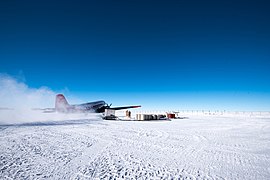
Lake Jan Skiway | |||||||||||
|---|---|---|---|---|---|---|---|---|---|---|---|
 | |||||||||||
| Summary | |||||||||||
| Airport type | Private | ||||||||||
| Operator | Ministry of Overseas | ||||||||||
| Location | Antarctic Plateau | ||||||||||
| Opened | February 9, 2020 | ||||||||||
| Elevation AMSL | 10,725 ft / 3,269 m | ||||||||||
| Runways | |||||||||||
| |||||||||||
Lake Jan (Reykani:Jan vatn),(Salisfordian:Lago di Jan) officially known as the Administrative Territory of Lake Jan is the region in Tierrasur claimed by Reykanes as a Reykani Overseas Territory. The main and largest station is the Leiðangursstöð II. It is named after the first Tierrasurian Reykani explorer Jan Aaron. The territory was founded and claimed by him in 1935. The Territorial claim become official in Reykanes in 1950 when they announced that all land and perspective territorial water from 60° East to 90° East of the continent is claimed by Reykanes. After the 1957 Coup, when the constitution was re-written, the claim was re-done to keep it's official status, reorganizing it in to a Overseas Territory and reaffirming the boundaries once again. The Official claim states:
With a spirit of openness, friendship, and democratic values, we, the Republic of Reykanes, are pleased to announce our claim over all land and prospective territorial waters within the specified limits on the continent, ranging from 60° East to 90° East of the Medirian.
Research activities in Tierrasur are primarily focused on understanding the continent's unique ecosystems, climate patterns, glaciology, and geology. Its highest peak is Grímsvötn which is 2,265 m high.
There is no permanent population, although there are 3 active research stations housing a maximum of around 50 scientists, the numbers fluctuating depending on the season. Two are occupied year-round, while the remainder is a seasonal summer station. In 2020 a new skiway was built near Leiðangursstöð II but so far only been used twice.
It is administered by the Ministry of Overseas, with a cabinet member, the Minister of the Overseas, currently held by Enóla Hólmkelsdóttir, in charge of issues related to the territory.
Contents
history
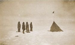
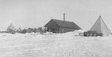
The primary purpose of Jan Aaron's travel to Tierrasur is to study the region's unique environment, conduct scientific experiments, and contribute to our understanding of various fields such as climate change, glaciology, oceanography, and biodiversity, however early Reykani research activities in Tierrasur rested entirely on whaling and sealing expeditions funded by ship owners, so most of his fund came from those sources. He set to travel to Tierrasur on 24 January 1935. The Antarctic Plateau was claimed for Reykanes by Jan Aaron, after he set up a base, called Leiðangursstöð I. The primary basis for the annexation were the Reykani explorations and the need to secure the Reykani whaling industry's access to the region, to secure funds for his scientific operations but his claim was never claimed by the government of the Grand Duchy of Reykanes.
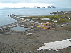
By the 1940s presence of whaling and fishing was at all time high in the area especially for Reykani whaling companies and remained that way till the 2010s. Ships from Reykanes remained in the region for large amounts of time, bringing all kinds of resources to survive weeks or even months. Whaling companies forced the Reykani Tierrasur program headed by Jan Aaron to establish a new outpost but on the coast for to ships have a resting point, threatening them with stopping the founding for the program or with other means. Eventually they established the Suðuríheiminum Outpost in 1944 on the coast, that was also part a Whaling Station, which still exist today
In 1947 disaster struck. A small earthquake hit Leiðangursstöð I in June, the entire base sunk down in the ground, resulting in abandoning the base. Luckily all samples were saved. Not enough funds were secured to rebuild the base, so it was fully abandoned. Some remains of the base is still visible in the sunken hole to this day.
After the 1949 Revolution, in the socialist era the government restarted the program in 1950 by building Leiðangursstöð II on a safer spot and bringing better equipment. It was bigger then the last one. In the same year the area was officially claimed by Reykanes. The territory was called the Land verkamanna (Land of the Workers) between 1950 and 1957. The main reason were of expanding its influence beyond its borders and re-secure the fishing grounds.
In the spirit of solidarity and collective progress, the Socialist Republic of Reykanes proudly proclaims its claim over all land and prospective territorial waters within the specified limits on the continent, ranging from 60° East to 90° East of the Meridian.
After 1957 the area claimed became a Reykani Overseas Territory.
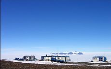
In 1993 a new research base was opened on the other side of the territory to expand the area that can be researched. Its called Leiðangursstöð III. Its not as big as Leiðangursstöð II but it brought new devices and storage facilites. Reykanes, like other nations, sent multiple scientific expeditions to Antarctica to conduct research and contribute to the understanding of the region's unique ecosystems and climate.
Geography
Topography
Lake Jan extends from 60° East to 90° East, defined by the first official claim in 1950. The region is all year covered by ice or snow. It is mostly flat, with 1/3rd of the area is ice sheets, with the mountainous region located with more inland. The tallest mountain is Grímsvötn which is 2,265 m high.
The area also holds the largest subglacial lake on the continent, the surface of this fresh water lake is approximately 3,000 m (9,842 ft) under the surface of the ice, which places it at approximately 400 m (1,312 ft) below sea level. The coastal area is called Hvalveiði Haf (Whaling Sea), a proposed name for a sea apart of the Southern Sea, however it is disputed, having been recognised or unrecognised multiple times in the past decades. There are some minor subantarctic volcanic islands on the coast but no one has ever step foot on them.
Climate
The climate of the region ranges from a subpolar climate in the north to a polar climate in the south.[30] The region has an extremely cold climate, with mean temperatures below 0 °C (32 °F) with frost and snowfall occurring throughout the year. The region experiences strong cold winds and blizzards. In the interior of the continent, the climate is colder and drier due to the higher latitude.
Administration
As per the Constitutional reform of 1957, the Tierrasurian claim is categorised under the Reykani Overseas Territories and falls under the jurisdiction of the Ministry of Overseas, controlled by the minister of the Overseas, a cabinet member in the Reykani Government, currently held by Enóla Hólmkelsdóttir, who is in charge of issues related to the territory.
Bases
Active bases
| Base | Image | Opened | Population | Type | Operator
|
|---|---|---|---|---|---|
| Suðuríheiminum | 1944 | 8 | Seasonal | Ministry of Overseas | |
| Leiðangursstöð II | 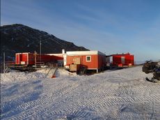
|
1950 | 30 | Permanent | Ministry of Overseas |
| Leiðangursstöð III | 1993 | 16 | Permanent | Ministry of Overseas
|
Closed bases
| Base | Image | Opened | Closed | Type | Operator |
|---|---|---|---|---|---|
| Leiðangursstöð I | 1935 | 1947 | permament | Reykani Tierrasur Expedition |
See also


