Geography of Creeperopolis
Jump to navigation
Jump to search
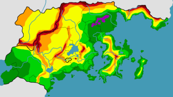
 Elevation map of Creeperopolis | |
| Continent | Sur |
|---|---|
| Region | Central Sur |
| Area | Ranked 4th |
| • Total | 10,486,679.8 km2 (4,048,929.7 sq mi) |
| Highest point | San Salvador Volcano (25,481 pies; 23,294 feet; 7,100 meters) |
| Lowest point | Imperial Depression (–145 pies; –133 feet; –41 meters) |
| Longest river | San Miguel River |
| Largest lake | Lake San Salvador |
| Climate | Humid north, semi-temperate south |
| Terrain | Mountainous along northern and western borders, central Creeperopolis, and the Atlántidan Peninsula, highlands in central Creeperopolis, lowlands along the coasts |
| Natural resources | Iron, gold, oil, coal, limestone, silver |
| Natural hazards | Storms, floods, earthquakes, volcanic eruptions |
| Environmental issues | Air pollution, water pollution, illegal dumping, deforestation |
Creeperopolis is the largest nation in the southern hemisphere and in Sur.
