Difference between revisions of "Salvadoran Range"
Jump to navigation
Jump to search
(Created page with "{{Infobox mountain | name = Salvadoran Range | native_name = Cordillera Salvadoreño | native_name_lang = | other_name = | photo = File:Cordillera de los Andes.jpg | photo_c...") |
m (Text replacement - "department" to "viceroyalty") |
||
| (One intermediate revision by the same user not shown) | |||
| Line 27: | Line 27: | ||
| width_orientation = | | width_orientation = | ||
| highest = [[Aconcagua]] | | highest = [[Aconcagua]] | ||
| − | | highest_location = [[San Miguel ( | + | | highest_location = [[San Miguel (viceroyalty)|San Miguel]], [[Creeperopolis]] |
| elevation_m = | | elevation_m = | ||
| coordinates = | | coordinates = | ||
| Line 35: | Line 35: | ||
}} | }} | ||
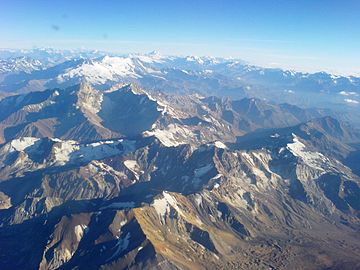
| − | The '''Salvadoran Range''' ([[Creeperian | + | The '''Salvadoran Range''' ([[Creeperian language|Creeperian]]: '''Cordillera Salvadoreño''') is a mountain range on the [[Southern Landmass]]. The mountain range marks the border between [[El Salvador]] and [[Creeperopolis]]. |
{{Creeperopolis topics}} | {{Creeperopolis topics}} | ||
Latest revision as of 01:19, 24 July 2024
| Salvadoran Range | |
|---|---|
 | |
| Highest point | |
| Peak | Aconcagua (San Miguel, Creeperopolis) |
| Naming | |
| Native name | Cordillera Salvadoreño |
| Countries | |
The Salvadoran Range (Creeperian: Cordillera Salvadoreño) is a mountain range on the Southern Landmass. The mountain range marks the border between El Salvador and Creeperopolis.
