Difference between revisions of "Imperial Depression"
Jump to navigation
Jump to search
| (7 intermediate revisions by 2 users not shown) | |||
| Line 1: | Line 1: | ||
{{Infobox valley | {{Infobox valley | ||
| name = Imperial Depression | | name = Imperial Depression | ||
| − | | other_name = | + | | other_name = Xichútepa Depression |
| − | | native_name = Depresión Imperial | + | | native_name = Դեպրեսիօն Իմպերիալ<br />Depresión Imperial |
| native_name_lang = | | native_name_lang = | ||
| translation = | | translation = | ||
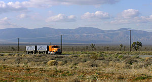
| − | | photo = | + | | photo = [[File:Antelope valley californie.jpg|300px|A truck on Creeperian Route 49.]] |
| − | | photo_caption = | + | | photo_caption = A truck on [[Creeperian Route 49]]. |
<!-- MAP --> | <!-- MAP --> | ||
| map = | | map = | ||
| Line 12: | Line 12: | ||
| map_caption = | | map_caption = | ||
<!-- Location --> | <!-- Location --> | ||
| − | | location = [[ | + | | location = |
| − | + | | country = [[Xichútepa (department)|Xichútepa]], [[Creeperopolis]] | |
| region = | | region = | ||
| state = | | state = | ||
| district = | | district = | ||
| − | | city = | + | | city = [[Ninguaque, Xichútepa|Ninguaque]] (largest) |
| relief = | | relief = | ||
| label = | | label = | ||
| Line 24: | Line 24: | ||
| coordinates_ref = | | coordinates_ref = | ||
<!-- Statistics --> | <!-- Statistics --> | ||
| − | | elevation = | + | | elevation = –145 pies <small>(–133 feet, –41 meters)</small> |
| elevation_m = | | elevation_m = | ||
| elevation_ft = | | elevation_ft = | ||
| Line 49: | Line 49: | ||
| topo = | | topo = | ||
| traversed = | | traversed = | ||
| − | | river = | + | | river = [[Ninguaque River]] (dry) |
<!-- Below --> | <!-- Below --> | ||
| footnotes = | | footnotes = | ||
| Line 55: | Line 55: | ||
}} | }} | ||
| − | The '''Imperial Depression''' ([[Creeperian | + | The '''Imperial Depression''' ([[Creeperian language|Creeperian]] – [[Iberic script|Iberic]]: ''Depresión Imperial''; Creeperian – [[Creeperian script|Creeperian]]: ''Դեպրեսիօն Իմպերիալ'') as a natural depression located in the department of [[Xichútepa (department)|Xichútepa]] of [[Creeperopolis]] which, at its lowest point, is 145 pies (133 feet, 41 meters) below sea level. |
| − | The | + | The largest city in the valley is [[Ninguaque, Xichútepa|Ninguaque]], near the site of [[Antonio Sáenz Heredia Air Force Base]]. |
| − | {{ | + | [[File:Imperial Depression Map.png|thumb|left|Location of the Imperial Depression in Creeperopolis.]] |
| + | |||
| + | {{Xichútepa Department}} | ||
{{Creeperopolis topics}} | {{Creeperopolis topics}} | ||
Latest revision as of 04:08, 1 April 2024
| Imperial Depression | |
|---|---|
 | |
| Floor elevation | –145 pies (–133 feet, –41 meters) |
| Naming | |
| Native name | Դեպրեսիօն Իմպերիալ Depresión Imperial |
| Geography | |
| Country | Xichútepa, Creeperopolis |
| Population center | Ninguaque (largest) |
| River | Ninguaque River (dry) |
The Imperial Depression (Creeperian – Iberic: Depresión Imperial; Creeperian – Creeperian: Դեպրեսիօն Իմպերիալ) as a natural depression located in the department of Xichútepa of Creeperopolis which, at its lowest point, is 145 pies (133 feet, 41 meters) below sea level.
The largest city in the valley is Ninguaque, near the site of Antonio Sáenz Heredia Air Force Base.


