Republic of Ferunia
Free Fascist Republic of Ferunia and the Ferunian Peoples | |
|---|---|
Motto: Por Liberato Nos Luctomo For liberty, we fight | |
Anthem: "Por Liberato!" | |
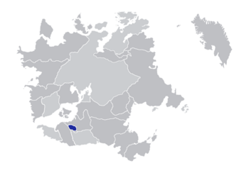
 Location of Ferunia in Ecros | |
| Status | Semi-recognized |
| Capital | Ferunia |
| Official languages | Feruno-Trurnian Iberic |
| Ethnic groups | Illyrians, Eisylians |
| Religion | Illyrian Catholicism, Atheism, Cauvunianism |
| Demonym(s) | Ferunian, Feruno |
| Government | De jure presidential republic under a de facto military dictatorship |
| Julio Andreo (LPF) | |
| Janoa Vileo (LPF) | |
| Legislature | Parliament |
| Senate | |
| House of Representatives | |
| Establishment | |
• Declared independence | July 21, 2006 |
• End of the First Ferunian Separatist War | November 15, 2008 |
• Beginning of the Second Ferunian Separatist War | May 2013 |
• End of the Second Ferunian Separatist War | July 2019 |
| July 13, 2024 | |
| Area | |
• Total | 70,329 sq mi (182,150 km2) (not ranked) |
| Population | |
• 2022 estimate | 2,330,696 (not ranked) |
| Currency | Oro (ORO) |
| Time zone | TMB-4 (Romano Standard Time) |
The Republic of Ferunia (Feruno-Trurnian Iberic: Republica de Ferunia, Illyrian Iberic: Repoleça de Ferunya, Eisylian Iberic: Repobleca de Ferunia), officially the Free Fascist Republic of Ferunia and the Ferunian Peoples, is a breakaway state located southwestern New Illyricum and bordering Kwazulu-Ciskei and Kersevonia, which is currently recognized by Pavulturilor. The nation is currently under a de facto military dictatorship led by President Julio Andreo, the leader of the Free Ferunian Army. During the Battle of Ferunia on July 13, 2024, Ferunian forces took control of Ferunia and currently use the city as the national capital.
The nation has a population of 2,330,696 most of whom live in the three central cities of Ferunia, Trurnia, and Ponturbe, on the Feruno River, the majority of whom do not openly consider themselves members of the Republic of Ferunia, with the official "loyal" population estimate released in 2017 by President Marco Chaka being 300,000. The territory claimed by the republic stretches 182,150 square kilometers (70,329 square miles) and covers all of the state of SE Ferunicum.
History
Geography
Southern and western Ferunia is mostly flat, with the end of the Andaluzian Mountains running into northeastern Ferunia near the New Illyrian border. All of Ferunia is warm year round, do to its proximity to the equator, and is classified under the Brauner Climate Classification as a tropical savannah (Aw). The Feruno River, Kei River, and the White River each run out from Solo Lake in northeast Ferunia, which flow through the nation into Kwazulu-Ciskei and Alo Rio.


