Geography of Monsilva
 | |
| Continent | Ostlandet |
|---|---|
| Region | Central Ostlandet |
| Area | Ranked 37 |
| • Total | 964,027 km2 (372,213 sq mi) |
| Coastline | 3,289 km (2,044 mi) |
| Highest point | Mount Yushan, 4,884 m (16,024 ft) |
| Lowest point | Kivu Ocean, 0 m (0 ft) |
| Longest river | Meihua River |
| Largest lake | Lin Sun Lake |
| Climate | subtropical |
| Terrain | mountainous in the west and inland, plains and forests in the east and coastal areas. |
| Natural resources | arable land, hydropower potential, silicon, zinc, copper, oil, natural gas, mercury, tungsten, aluminium, rare earth elements, medicinal agriculture |
| Natural hazards | typhoons; damaging floods; tsunamis; earthquakes |
| Environmental issues | air pollution; water pollution; deforestation; soil erosion; desertification |
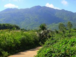
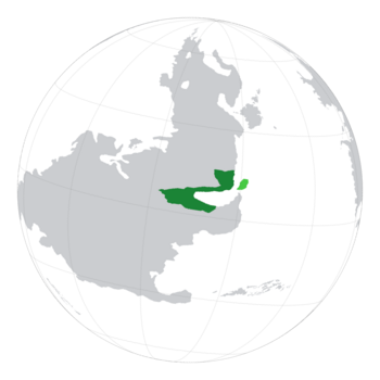
Monsilva is located on the eastern side of Central Ostlandet. The country's borders are defined by its sloping physical geography, with its eastern border defined by the Kivu Ocean, and its western border defined by mountain ranges. The coastal states of Monsilva consist mostly of fertile lowlands, foothills and forests and hold the vast majority of Monsilva's agricultural output and human population. The western and inland regions of Monsilva consist of fewer people due to its hilly and mountainous terrain. The inland south-east of Monsilva is where the country's only sub-tropical rainforests are located, such as the Minxiong South National Park. Monsilva's subtropical climate prevents it from having any deserts, however artificial desertification, specifically in Nanyan, has created artifical desert-like environments.
Traditionally, the Monsilvan population has been focused on the country's coast, which is partly the reason behind Monsilva's thin and densely-populated nature. This has been due to the highly arable land located on the coast which kickstarted Monsilva's still growing agricultural industry. However, the country's mountains are still a large part of its culture, with Monsilvan emperors, starting from the Zhou dynasty, choosing to be located among the mountains in places such as Sanzhong. Amking, the capital and largest city in Monsilva, which holds around a fifth of the Monsilvan population, has Monsilva's most habitable land, and has been the center for Monsilva's population for centuries due to its agricultural potential and ability to be used as an economic centre and trading hub.
The Monsilvan Republic has a land area of approximately 964,027 km2 (372,213 sq mi), placing it 37th in Terraconserva.
Contents
Physical Geography
Generalities
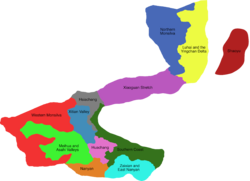
The topography of Monsilva has been divided by two different official authorities. In 1982, the Monsilvan government split Monsilva into 5 heterogeneous regions based off the country's administrative divisions, namely Northern Monsilva (Leibo, Luhai, Maguan and Meixian), Central Monsilva (Bazhong, Weishi and Xiaogu), Western Monsilva (Wuzhong and Xishanjia), South Monsilva (Huachang, Nanyan and Zaixian), and Eastern Monsilva (Amking and Donguan). However, the Monsilvan Society for Geography (山国地理学会) revised these divisions in 1989 to be more fitting to the topographical features of Monsilva. The MSG's original 11 divisions are as follows: Western Monsilva (includes the western half of Xishanjia and Wuzhong, as well as the north-west of Weishi), Meihua and Chahe Valleys (the lowlands that sit between the Shannan Mountains and the Chungfen Mountains), Nanyan, Huachang, Zaixian and East Nanyan, Southern Coast, Xitian Valley, Hsiachang (Xiaogu panhandle and eastern Weishi), Xiaoguan Stretch (Xiaogu and Maguan), Luhai and the Yingchan Delta (coastal Meixian and Luhai), and Northern Monsilva (inland Meixian and Leibo). These eleven regions are mostly topographically homogeneous, ranging from open grassy plains and deep valleys to snow-capped mountains and terraced hills. The country's rugged terrain in the west has presented challenges for the construction of overland transportation infrastructure and has required extensive terracing to sustain agriculture. However, the mountainous terrain has given Monsilva plenty of mineral resources, one of the highest hydropower outputs in Terraconserva, and has helped develop tourism. In 2024, with the admission of Shaoyu into the Monsilvan Republic, the MSG added a twelfth division aptly named 'Shaoyu'.
M.S.G. Divisions
Western Monsilva
The Monsilvan Society for Geography defines its 'Western Monsilva' region as being the mountainous terrain that lies in the west of the country within the states of Xishanjia, Wuzhong and Weishi. It consists of Monsilva's tallest mountains, including its tallest, Mount Yushan. The mountains of Western Monsilva are divided into three mountain ranges: the Weishi Mountain Range, the Han Mountain Range and the Shannan Mountain Range. Although all three ranges are generally similar, they have unique features that allow them to be identified individually from each other. Western Monsilva is mostly uninhabited, with the largest settlements barely surpassing classification as villages. The terrain being difficult to navigate results in people going missing or being injured while attempting to navigate. It is also difficult to maintain, with occasionally dangerous plants and animals coming close to man-made trails and settlements.
The Weishi Mountain Range forms the northern mountains in the Western Monsilva region, and also defines the border between the state of Weishi and Akvarelusus. It holds six of the ten tallest mountains in Monsilva and has recorded some of the coldest temperatures in the country. Many of the mountains in the range are unclimbable due to their steep and jagged nature, however others, including Mount Yushan, are more climbable and have multiple trails leading to the peak.
The Han Mountain Range forms the entire western third of the state of Wuzhong and separates Monsilva from Baltanla. It holds Monsilva's longest railway tunnel, at 49.5km long. It also holds more than 52 percent of all of Monsilva's mountain hiking trails, and is home to over 40 Shaolin temples devoted to Monsilvan folk religion and Buddhism. The Han Mountain range has been a significant part of Monsilva's culture, with many surviving royal paintings from the country's dynastic period being of landscapes near the mountains.
The Shannan Mountain Range is found in Xishanjia and is the warmest mountain range out of the three. It is known for its unique pillar-like rock formations, and was one of Monsilva's first officially designated National Parks. The formations have recieved large amounts of attention from geographic experts and tourists due to their uniqueness. The formations are the result of many years of physical, rather than chemical, erosion. Much of the weathering that forms these pillars is the result of expanding ice in the winter and the plants that grow on them.
Meihua and Chahe Valleys
The Meihua and Chahe Valleys are large flat areas lying between the Nanhua, Chungfen, Shannan and Han mountain ranges. It lies within the states of Wuzhong, Xishanjia, Weishi and Nanyan.
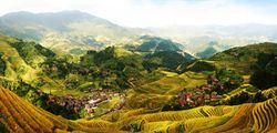
It is predominantly filled with agricultural land growing products like wheat, rice, coffee, fruits, and many more food products. As well as this, it has plenty of pastures filled with animals such as cattle, chickens, pigs and sheep. Other than agricultural land, the valleys do have some significant settlements, the largest of which being Wodai, but there are also others such as Sanzhong and Taimali. Notable geographic features within the valleys include rice terraces, such as the Ren'ai Rice Terraces and waterfalls, such as the Guangxi Waterfall.
Nanyan and Huachang Regions
The Nanyan region defined by the Monsilvan Society for Geography consists of the central region of the state of Nanyan as well as a part of southern Huachang. It is characterised by historic deforestation and mining which has damaged the environment. However, this environment has been improving over the last decade due to recovery efforts initiated by the Monsilvan government in the early 2000s. Originally, the region was dominated by sub-tropical rainforest, grasslands and savannah.
Unlike the state borders of Huachang, the MSG defines the Huachang Topographical Region as the valleys that lie between the Beihua Mountains, that mark the border between the states of Amking and Huachang, and the Nanhua Mountains, which mark the border between Huachang, Xishanjia and Nanyan. The region's topographical development has been characterized by its location surrounded by mountains. The Meihua River flows through the center of the region and provides the region with a source for its agriculture.
Zaixian and East Nanyan
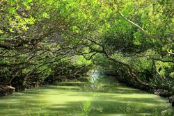
The Zaixian and East Nanyan, as the name suggests, is an MSG Topographical Region which includes all of the state of Zaixian as well as the easternmost area of Nanyan. It is categorized by its almost tropical environment, including rainforests and wetlands. It is home to the Xikou and Minxiong South national parks. Xikou is one of Monsilva's largest national parks, consisting of almost the entirety of Zaixian's rainforests. The region is the warmest in Monsilva, with temperatures frequently reaching above 40 degrees celcius. It is also the closest part of Monsilva to the equator. The largest settlements in the region are Baoan and Yilan, the capitals of Zaixian and Nanyan respectively.
Southern Coast
The Southern Coast Topographical Region defined by the Monsilvan Society of Geography consists of the states of Donguan, Amking, the easternmost part of Huachang and the coastal regions of Bazhong. In the south it is bounded by the Bay of Monsilva and the hills and forests of southern Donguan and Zaixian, while further north it is defined by the Shuangfang Mountains of central Bazhong. The topography of the Southern Coast is defined by fertile lowlands and plains that are in proximity to the coast. It is also the most populated region of Monsilva, with settlements including the capital of Monsilva, Amking, as well as major cities such as Shangrao, Waiping and Chishang.
Xitian Valley and Hsiachang Regions
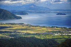
The Xitian Valley lies between the Shuangfang, Chungfen and Nantou mountain ranges and is named after the River Xitian which originates from Lake Xitian located in north-west Bazhong. The valley is famous for its small villages that scatter the grasslands and forests that lie within it. However, larger settlements such as Yuchi, Guobei and Wuden also sit within the valley, but are all found around Lin Sun Lake in Weishi, the largest lake in Monsilva.
Hsiachang consists of the Shuangfang Mountains, north-east Weishi, and the Xiaogu Panhandle. Hsiachang is defined by its hilly and mountainous terrain, with the flattest part of the region being the Lunhuang Valley, in which the largest settlement, also named Lunhuang, is located. The Lunhuang Valley, despite being flatter than the rest of the region, is still well above sea level. It was created from erosion from the Gaoping River, one of the many rivers that flows into the Zhongdao River, which also flows through the valley.
Xiaoguan Stretch
The Xiaoguan Stretch, a portmanteau of Xiaogu and Maguan, the two states that make up the region, consists of grasslands simalar to those found on the southern coast of Monsilva. As a coastal region, it hosts a large portion of the Monsilvan population and is also responsible for most of Monsilva's animal products industry, with many pastures dedicated to cattle, sheep and pigs being located within the region. Plenty of major rivers flow into the Bay of Monsilva via the Xiaoguan Stretch, including the Zhongdao, Tamsui, Puzi and Tao Rivers. The Huanglong River, Monsilva's widest river, also flows into the bay through Maojie, the largest city in the region. The region is also more susceptible to earthquakes than anywhere else in the country, with the largest earthquake in Monsilva's recorded history being the 2011 Maojie earthquake which had a magnitude of 7.3 ML.
Luhai and the Yingchan Delta
Probably the largest of the Monsilvan Society of Geography's topographical regions, the Luhai and the Yingchan Delta region consists of almost all of Meixian east of the Meixian Mountains as well as the non-mountainous regions of Luhai. The region is dominated by low hills, fields and pastures, making up Monsilva's largest consistent region of arable land. It has been a vital part of Monsilva's agricultural industry for hundreds of years and control over the region was utilised during historical conflicts to weaken the government due to its importance. This characteristic has also lead to millions of people inhabiting the region, with Monsilva's second and third largest cities, Luhai and Menchi, both being located within the region. The Yingchan Delta, located in Menchi, has historically been susceptible to flash floods due to the flat, low lying islands that the delta consists of. However, the importance of lowering the impact of the flooding due to the large population in the area has lead to significant, and so far successful, anti-flooding measures being put in place across the region.
Northern Monsilva
The Northerm Monsilva Topographical Region is defined by the MSG as consisting of the Meixian and Gaobei mountain ranges. The mountains in this region are famous for their sloping edges, with the tallest of these mountains, which are found in Leibo, being used for winter sports such as skiing and snowboarding. It is the only region in Monsilva to host a ski resort, the Daxueshan Ski Resort. However, despite the regions mountainous nature there are valleys in which settlements have developed, the largest of which is Haimao, the capital of Leibo.
Shaoyu
Shaoyu Island hosts a similar climate to its nearest mainland state, Meixian, with coastal areas being arable and warm and the mountainous inland being less inhabitable and much cooler. The island is characterised by its ring of settlements on the coast surrounding the steep Shaoyu Mountains.
Rivers
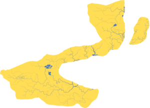
Monsilva has thousands of rivers, including ones originating in and outside the country's borders. Monsilva's coastal nature has lead to it hosting a large portion of the mouths of many of central Ostlandet's rivers. The vast majority of rivers flow west to east, from the many mountain ranges on Monsilva's inland borders and into the Bay of Monsilva or the Kivu Ocean. The Meihua River, which rises in the Shannan Mountains of Xishanjia, flows through southern Monsilva and enters the Bay of Monsilva through the city of Amking. The Meihua is around 1,200 kilometres long, and is Monsilva's longest river. It is closely followed by the Cha River which flows through central Monsilva, rising in the Han Mountains of Wuzhong and flowing through the cities of Wodai, Sanzhong and Taimali before reaching Lin Sun Lake. Other long rivers in Monsilva include: the Chun River, which rises in the Gaobei Mountains and flows through Haimao into the state of Luhai, where it then flows through Tsingyi before making its way across the state to flow into the Kivu Ocean via Luhai City; the Tao River, which originates in the Meixian Mountains not far from the Giant Panda National Park and flows southwards towards the city of Taoyuan, which is where it flows into the Bay of Monsilva. The Tamsui and Puzi rivers both flow through Maguan, and although their Monsilvan sections are relatively short, they are much longer and originate in the country of Akvarelusus.
Monsilva's rivers developed much more prematurely than is common for rivers, with many of them having created vast valleys through centuries and even millennia of erosion. Major examples include the Meihua, Cha and Xitian rivers which have all created large valley regions that often have their own topographical features that differ from each other as well as the rest of the country.
Monsilva's territorial waters consist of the majority of the Bay of Monsilva, as well as a small portion in the Kivu Ocean by the state of Luhai. Monsilva also claims the territorial waters of Shaoyu Island. The coastline of Monsilva ranges from cliff edges to sandy beaches. The Xiaoguan Stretch and Bazhong have the largest sandy beaches in Monsilva, while the northern and southern coasts are more rocky.
Yingchan Delta
The Yingchan Delta is the largest delta in Monsilva, resulting from the divergence of the Yingchan River which flows from Lake Changzhi in northern Meixian towards the Kivu Ocean in the east. The river begins diverging just past the town of Leliu where it splits into more than 10 different tributaries and estuaries. By the time the river meets the city of Menchi, it has diverged over 50 miles wide creating around 15 islands on which the city lies upon.
Before the urban expansion of Menchi, the delta was covered in thick marsh and forested land that hosted a wide range of flora and fauna. It was perfect for agriculture, and this was almost immediately identified by the first Monsilvans who reached the delta, who begun growing a wide range of crops in the area, including rice. The agricultural importance of the delta has been utilised throughout history in economics, politics and business.
Chahe Valleys
The Chahe Valleys in Wuzhong, Taimali and Xishanjia, formed by the Cha River, are well known for their unique geographic formations. The most famous of which is the Cha River's divergence at the feet of the Han Mountains into several tributaries that then converge after several hundred kilometres near the town of Nanjue. In the middle of the divergence is the city of Wodai, Monsilva's 7th largest and furthest westward city. Similar to the Yingchan Delta, the Cha River Divergence provided good agricultural land that was important throughout Monsilva's history and is the reason behind the grouping of population in such a remote part of the country.
Although the rivers were good for agriculture, they were also extremely prone to flooding, and would frequently break their banks during the rainier months of the years. The predictable nature of the flooding however has allowed Monsilvans to develop countermeasures against the floods. Since the 19th century with advancing technology, the impact of the floods have become negligible.
Geology and natural resources
Monsilva has significant mineral reserves, producing large quantities of mercury, zinc, silicon, aluminium, bauxite, tungsten and copper. Monsilva is also one of the largest producers of rare earth elements such as yttrium, lanthanum and dysprosium. Although in much smaller quantities, Monsilva also produces uranium, natural gas, oil, tin, manganese and iron. Monsilva also has an extremely high hydropower potential due to its wide valleys and steep rivers.
Land use
Based on estimates made in 2006, about 67.8 percent of Monsilva's total land area is dedicated to pasture or is forested. Around 12.9 percent is used for permanent or temporary crops, around 30 percent is used as pasture, and the final 24.9 percent is forest. Monsilva's extreme use of land for agriculture has resulted in the country producing significantly more product than is necessary for its population of 50 million. This has allowed Monsilva to become a major agricultural exporter for countries all across Terraconserva.
Wildlife
Monsilva's position in central Ostlandet has allowed it to host a wide range of wildlife. Notable fauna in Monsilva include the giant panda, the Monsilvan mountain pheasant, the Monsilvan mountain cat, the leopard cat and the Monsilvan black bear. As Monsilva is a part of the continent, it shares millions of species of fauna with many other countries on the continent, however Monsilva's mountains have still allowed endemic species to form, such as the giant panda, the Monsilvan ferret badger, and the odd-scaled snake. There has historically been a problem with trade in endangered species taking place in Monsilva, however extensive laws against these activities including hefty fines of over ¥70,000 have reduced this issue massively.
Human geography
History
Monsilvan history is often explained in terms of several strategic areas that are defined by particular topographic limits across the country. It has been determined that the heart of the original Monsilvan populations was the Huachang Valleys around the Meihua River. Those people expanded militarily and demographically towards the coast, forming large populations from Donguan to the edge of the modern day state of Amking. Over time, the Monsilvan people took control over the vast majority of modern day southern Monsilva, while other ethnic groups were pushed southward or northward. It was at this point that the boundaries of Monsilva begun forming, which were largely defined by mountain ranges and rivers. It was in the 9th century BCE that the first Monsilvan dynasties begun forming such as the Xia and Xin dynasties.
Monsilva's geography has played an important role in the country's military history, with the earliest wars that took place in Monsilva having both sides utilising geography to thier advantage. The Hengchun Corridor, located on the border between the modern states of Bazhong and Xiaogu has been one of the most strategic areas in Monsilva's military history. This is emphasised by many of Monsilva's battles involving conflicts between the north and south of the country, which is divided by the corridor.
Demographic geography
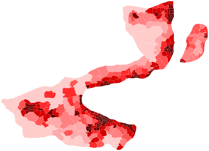
The demographic occupation follows the topography and availability of former and current arable lands. The population of Monsilva has been focused along the coast for thousands of years, which is still clear today. The Kaosueh Mountain Range, which includes the Gaobei, Meixian, Akewa, Yuanchan, Weishi, Han and Shannan mountain sub-ranges, is responsible for the concentration of Monsilvans along the Bay of Monsilva and the thin nature of Monsilva's national boundaries.
Along with hundreds of smaller non-native ethnic groups, there are three major ethnic groups reside in Monsilva: Monsilvans, Baltanese and Byasanese. Monsilvans are by far the largest group, being approximately 88 percent of the population, and live across the entire country. Baltanians, who were historically the largest ethnic group in the Han dynasty, reside across the entire country as well, but are concentrated in the west which is closer to the nation of Baltanla. Most Byasanese people reside in the south of the country and in urban areas.
Religiously, Monsilva is divided into Monsilvan folk religion and Buddhism. Buddhism was the first non-pagan religion to arrive in Monsilva, it was brought over by Buddha himself in the 6th century BCE, and has remained in the country, with the largest followings being in western and southern Monsilva, while Monsilvan folk religion and irreligious groups are found in the east and north. No religion has a majority, although Monsilvan folk religion, which itself also uses teachings from Buddhism as well as Taoism and Confucianism, is followed by 48.6 percent of the population. Buddhism is followed by 27.5 percent of the population.
Administrative geography
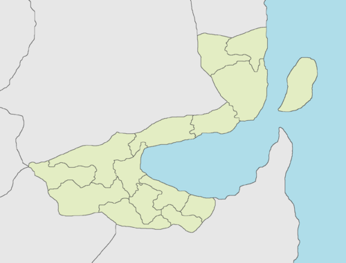
The origins of Monsilvan administrative geography today are from the original counties drawn up in 1905 during the Kingdom of Monsilva. These counties were organized into prefectures in 1953 which closely resemble Monsilva's current states. The prefectures were re-organized at the start of the martial law period in 1963 and remained the same until 1984. In 1983, Monsilva established its federal system which granted devolved powers to each of Monsilva's states (which were the same as the pre-1978 prefectures). In 1984, less than a year after federalization, the states were re-organized for a final time into the 14 states Monsilva has today.
Monsilva's districts (second-level division), counties (third-level division) and municipalities (fourth-level division) have been changed multiple times between 1984 and the present day. The most recent change was in 2023 with a major re-organization of all divisions and the addition of legislative constituencies which were created to be used solely for federal elections, removing the relationship between Monsilva's counties and the parliament.
In June 2023, the Monsilvan government officially claimed Shaoyu Island which lies off the coast of Luhai, as a 'territory'. In early 2024, a few months after the conclusion of the OU military intervention in Akvatika, Shaoyu was admitted as Monsilva's fifteenth state.
Agriculture
Agriculture has been a major part of the Monsilvan economy for hundreds of years, including after the beginning of industrialization in the country in the mid 19th century. About 15.5 percent of Monsilva's GDP is dedicated to agriculture, which contributes a large portion of Monsilva's labor force working in agriculture. Monsilva's main agricultural exports are rice, tea, poppies (medicinal), wheat and fish. Monsilva exports agricultural products across Ostlandet and across the Kivu Ocean towards western Ecros.
Over the past 50 years, Monsilva's total arable land has been declining due to expanding urbanization and preservation. However a large portion of this unused arable land is unneeded as Monsilva currently uses around 13 percent of its land area for crops and pastures which already allows it to produce 52 percent of its agricultural needs. Monsilva's agricultural land availability is divided into two halves, with half of the country being too mountainous to host crops or pastures, while the over half being almost all eligible for crop growth.
Territory and boundary disputes
The national boundaries of Monsilva can be dated back to Monsilva's dynastic period, more specifically with the founding of the Han dynasty in 60 CE. When the dynasty was founded, its boundaries, along with the boundaries of the Jin, Zhong, Tsao and Song dynasties, create an overall boundary that is strikingly similar to the current borders of Monsilva. However, it wasn't until 1201 CE, when the Zhou dynasty was formed, that Monsilva's current borders became visible. These borders have remained so little changed over a long period of time due to the impracticality of claiming land beyond the physical boundaries that lie on Monsilva's current borders such as mountains, wide rivers or channels. However, a major territory that has periodically been a part of Monsilva is the island of Shaoyu, which was last under Monsilvan control from 1732 to 1828, after which it was seized by the Empire of Jackson during the Monsilvan Civil War. The island was also under the administration of the Beining Heavenly Kingdom (a Monsilvan separatist state) from 1414 to 1500, and part of the Zhou dynasty from 1234 to 1414.
All except one of Monsilva's territorial disputes throughout its entire recorded history has been resolved, either through war or diplomacy. The only territorial dispute still ongoing with Monsilva is over Shaoyu Island. Which was administered by Zloveshchiy from 1969 to 2023, but after a successful OU intervention, is now administered as Monsilva's fifteenth state. The island was seized by Jackson in 1828, which was the beginning of the dispute, however this only lasted two years until 1830, when the Kingdom of Great Shan was dissolved in favor of the Kingdom of Monsilva which rescinded the claim over the island until 1963. In 1963, the military government of Shao Yaoting was created, which claimed the island of Shaoyu (known as Niao Dao at the time). This soured relations with Jackson, and lead to them rejecting to return the island to Monsilva and instead granting it to Zloveshchiy in 1969 out of spite for the hostile government. In 1984, after the establishment of the democratic Monsilvan Republic in 1978, the island's dispute had returned to only de facto, with the Monsilvan government not officially recognizing the island as its own, but government officials often referring to the island as if it should be under Monsilvan administration. In 2023, the dispute was fully re-initiated with the government of Lin Yao-tang officially recognizing Shaoyu Island as a territory of the Monsilvan Republic. After the OU military intervention in Akvatika in September 2023, Monsilva took over administration of the island but the dispute remains.
Border security
The security and strength of Monsilva's borders is entirely dependent on the location of the section of the border in question. This is not only due to the political nature of the borders, but also due to the physical geography of the country. Monsilva's borders are mostly defined by mountains, which results in the majority of the Monsilvan population living away from the country's borders. The Baltanla-Monsilva border, Monsilva's shortest border section, is found in west Wuzhong and is the least guarded of Monsilva's borders due to the two country's positive relations through Global ACES and the Ostlandet Union.
Monsilva's longest border is that with Akvarelusus. However, the vast majority of the border is defined by steep, uncrossable mountains. The largest and most used border crossing between Monsilva and Akvarelusus is located in the Huanglong Valley of the Akewa Mountains in the state of Maguan.
In contrast to Monsilva's other borders, the Monsilva-Zloveshchiy border is highly guarded, and although border crossings have operated in the past, they have been closed since June 2023 due to the ongoing territorial dispute between the two countries over the island of Shaoyu. Tall metal fences are found all along the border and are visible from the cities of Guangfu and Lunbei, the largest settlements on the border. Crossings are guarded by military personnel on both sides.
Climate and environment
Climate

Although Monsilva is not one of the largest countries in Terraconserva, it hosts a somewhat diverse climate, ranging from tropical in the far south, to tundra in the mountains of the west and north. During the summer, the monsoon winds carry warm and moist air from the south and delivers the vast majority of annual precipitation throughout the country. However, during the winter, cooler airs originating from the North Kivu ocean bring comparatively cooler and drier conditions. Despite Monsilva's proximity to the equator, the geography of the country, particularly its position along the Bay of Monsilva, has given it complex climatic patterns.
The lowest temperatures recorded in Monsilva are found at the peaks of the Weishi, Han and Gaobei mountains, which can reach altitudes of almost 5 kilometres. These temperatures can dip to well below −5 °C (23 °F). In contrast, the warmest temperatures in Monsilva are found in its most tropical region, found in Zaixian, where temperatures can reach as high as 40 °C (104 °F). Precipitation is largely concentrated in the warmer months, with occasional monsoons, typhoons and tropical storms reaching Monsilva during the summer months.
Monsilva's mountains have a significant impact on Monsilva's weather, with mountains often preventing rain clouds that are passing over north and central Ostlandet from reaching most of Monsilva. This also works the other way around, with clouds that are approaching from the Kivu Ocean being stopped from passing southward beyond Monsilva due to the Shannan Mountains.
Environment
Air pollution, originating from Monsilva's large manufacturing industry, is a developing issue, along with water pollution from certain industrial areas of the country. Despite the prevalence of these issues, the impact they are having on Monsilva's environment is decreasing, likely due to the development of more eco-friendly company policies and stricter environmental laws being introduced by the government. However, some problems that have existed in the past, such as deforestation and desertification in Monsilva's south, has resulted in a large permanent loss in agricultural land in the region, as well as a long lasting economic impact.
See also
- List of natural disasters in Monsilva
- List of rivers in Monsilva
- List of mountains in Monsilva
- Outline of Monsilva

