Difference between revisions of "Districts of Gjorka"
Jump to navigation
Jump to search
| (19 intermediate revisions by the same user not shown) | |||
| Line 7: | Line 7: | ||
| alt_name4= | | alt_name4= | ||
| − | | map= | + | | map= {{Districts of Gjorka imagemap|thumb=no|position=center}} |
| category= Federated state | | category= Federated state | ||
| territory= [[Gjorka]] | | territory= [[Gjorka]] | ||
| Line 82: | Line 82: | ||
!Capital | !Capital | ||
|- | |- | ||
| − | | <center>[[File:NorthernGjorkaMap.png|100px]] <br> | + | | <center>[[File:NorthernGjorkaMap.png|100px]] <br> {{flagicon image|Eureka Flag.svg}} [[Northern Gjorka]] </center> |
| [[Éire]] | | [[Éire]] | ||
| [[Elkton]] | | [[Elkton]] | ||
| − | | | + | | 8,900,457 |
|- | |- | ||
| <center>[[File:RoscommonMap.png|100px]] <br> [[File:Flag_of_Ulster.svg|border|25px]] [[Roscommon]] </center> | | <center>[[File:RoscommonMap.png|100px]] <br> [[File:Flag_of_Ulster.svg|border|25px]] [[Roscommon]] </center> | ||
| colspan="2" | <center>[[Broadford]]</center> | | colspan="2" | <center>[[Broadford]]</center> | ||
| − | | | + | | 3,183,893 |
|- | |- | ||
| − | | <center>[[File:GjorkaCityMap.png|100px]] <br> | + | | <center>[[File:GjorkaCityMap.png|100px]] <br> {{flagicon image|GjorkaCityDistrictFlag.png}} [[Gjorka City (District)|Gjorka City]] </center> |
| colspan="2" | <center>[[Gjorka City]]</center> | | colspan="2" | <center>[[Gjorka City]]</center> | ||
| − | | | + | | 10,433,234 |
|- | |- | ||
| <center>[[File:ProtterlandMap.png|100px]] <br> [[File:ShannonErne.svg|border|25px]] [[Protterland]] </center> | | <center>[[File:ProtterlandMap.png|100px]] <br> [[File:ShannonErne.svg|border|25px]] [[Protterland]] </center> | ||
| colspan="2" | <center>[[Rusynia]]</center> | | colspan="2" | <center>[[Rusynia]]</center> | ||
| − | | | + | | 6,040,987 |
|- | |- | ||
| − | | <center>[[File:DundalkMap.png|100px]] <br> | + | | <center>[[File:DundalkMap.png|100px]] <br> {{flagicon image|Flag of Gagauzia.svg}} [[Dundalk (District)|Dundalk]] </center> |
| − | | [[ | + | | [[Hampden]] |
| [[Dundalk]] | | [[Dundalk]] | ||
| − | | | + | | 5,734,235 |
|- | |- | ||
| − | | <center>[[File:LouthMap.png|100px]] <br> | + | | <center>[[File:LouthMap.png|100px]] <br> {{flagicon image|Flag of Cumberland, United Kingdom.svg}} [[Louth]] </center> |
| colspan="2" | <center>[[Camden]]</center> | | colspan="2" | <center>[[Camden]]</center> | ||
| − | | | + | | 5,092,077 |
|- | |- | ||
| <center>[[File:InnerKingdomDMap.png|100px]] <br> [[File:UnityFlag.svg|border|25px]] [[Inner Kingdom (District)|Inner Kingdom]] </center> | | <center>[[File:InnerKingdomDMap.png|100px]] <br> [[File:UnityFlag.svg|border|25px]] [[Inner Kingdom (District)|Inner Kingdom]] </center> | ||
| colspan="2" | <center>[[Canton]]</center> | | colspan="2" | <center>[[Canton]]</center> | ||
| − | | | + | | 6,378,591 |
|- | |- | ||
| − | | <center>[[File:IveraghMap.png|100px]] <br> | + | | <center>[[File:IveraghMap.png|100px]] <br> {{flagicon image|The Fenian Flag (1858).svg}} [[Iveragh]] </center> |
| [[Pimlico]] | | [[Pimlico]] | ||
| [[Enniskerry]] | | [[Enniskerry]] | ||
| − | | | + | | 3,625,446 |
|- | |- | ||
| − | | <center>[[File:GreaterNomakoaMap.png|100px]] <br> | + | | <center>[[File:GreaterNomakoaMap.png|100px]] <br> {{flagicon image|Flag of Kelley, Iowa.svg}} [[Greater Nomakoa]] </center> |
| colspan="2" | <center>[[Nomakoa]]</center> | | colspan="2" | <center>[[Nomakoa]]</center> | ||
| − | | | + | | 12,007,487 |
|- | |- | ||
| <center>[[File:GlenveagMap.png|100px]] <br> [[File:House_Flag_of_the_Australasian_United_Steam_Navigation_Company.svg|border|25px]] [[Glenveag]] </center> | | <center>[[File:GlenveagMap.png|100px]] <br> [[File:House_Flag_of_the_Australasian_United_Steam_Navigation_Company.svg|border|25px]] [[Glenveag]] </center> | ||
| [[Patapsco]] | | [[Patapsco]] | ||
| [[Drogheda]] | | [[Drogheda]] | ||
| − | | | + | | 3,516,635 |
|- | |- | ||
| − | | <center>[[File:BaltimoreDMap.png|100px]] <br> [[File:Calvert_family_banner.svg|border|25px]] [[ | + | | <center>[[File:BaltimoreDMap.png|100px]] <br> [[File:Calvert_family_banner.svg|border|25px]] [[Rosemont]] </center> |
| colspan="2" | <center>[[Baltimore]]</center> | | colspan="2" | <center>[[Baltimore]]</center> | ||
| − | | | + | | 7,723,155 |
|- | |- | ||
| + | !rowspan="2" | Autonomous District | ||
| + | ! colspan="2" | Cities | ||
| + | !rowspan="2" | Population | ||
| + | |- | ||
| + | !Largest | ||
| + | !Capital | ||
| + | |- | ||
| + | | <center>[[File:DontalamhMap.png|100px]] <br> [[File:DontalamhFlag.png|border|25px]] [[Dontalamh]] </center> | ||
| + | | [[Port Thior]] | ||
| + | | [[Nua Ross]] | ||
| + | | 501,354 | ||
|} | |} | ||
| − | + | {{Gjorka topics}} | |
[[Category:Gjorka]] | [[Category:Gjorka]] | ||
[[Category:Terraconserva]] | [[Category:Terraconserva]] | ||
| + | [[Category:Districts of Gjorka]] | ||
Latest revision as of 10:34, 28 March 2024
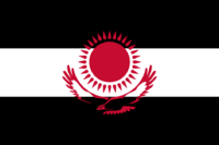
| Districts of Gjorka Ceantair Gjorka | |
|---|---|
  | |
| Category | Federated state |
| Location | Gjorka |
| Number | 11 |
| Government |
|
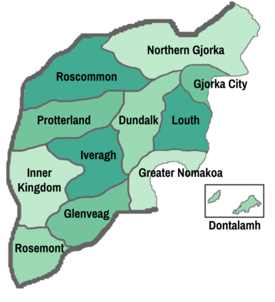
The Districts of Gjorka are sub-national administrative divisions within Gjorka. Each of the Eleven Districts were created by the Constitution of Gjorka, and amendments to the constitution have changed their shape and size. The constitution does not mandate a number of 11 districts, however since their creation no new districts have been added nor any destroyed. Districts have limited legal authority over their respective areas. Each district has their own assembly elected by the people, and a governor appointed by the ruling president for 10 years. However, these assemblies have very limited authority to due the superior nature of Federal Law, and thus in practice there is very little difference in law from district to district.
Districts of Gjorka
| District | Cities | Population | |
|---|---|---|---|
| Largest | Capital | ||
 |
Éire | Elkton | 8,900,457 |
 |
3,183,893 | ||
 |
10,433,234 | ||
 |
6,040,987 | ||
 |
Hampden | Dundalk | 5,734,235 |
 |
5,092,077 | ||
 |
6,378,591 | ||
 |
Pimlico | Enniskerry | 3,625,446 |
 |
12,007,487 | ||
 |
Patapsco | Drogheda | 3,516,635 |
 |
7,723,155 | ||
| Autonomous District | Cities | Population | |
| Largest | Capital | ||
 |
Port Thior | Nua Ross | 501,354 |