Abersiania
United Archipelago of Abersiania Abaershaun | |
|---|---|
|
Flag | |
Motto: Wij staan verenigd! (We stand united) | |
| Location | Central Ecros |
| Capital | Schoefengen |
| Largest city | Capital |
| Official languages | Abersianian, Jackian |
| Ethnic groups (2021) | |
| Religion (2022) |
|
| Demonym(s) |
|
| Government | Constitutional Monarchy |
| David Schaunesten | |
| Population | |
• 2023 estimate | 18,000,950 |
| GDP (nominal) | estimate |
• Total | 829,774,913,360 Quebecshirite Credit |
• Per capita | ~45,998 Quebecshirite Credit |
| Currency | Abersianian Pound (Ab£) |
| Time zone | AMT +6 (Kivuian Mountain Time, KMT) |
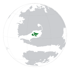
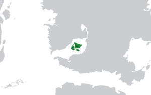
Abersiania (Abaershaun) is a nation situated off of the south west coast of Mainland Ecros, and is a collection of around 40 islands. Abersiania has been inhabited by various nomadic tribes until 576AD, when one of them, the Violeshen, created permanent settlements on the biggest island, Maufen. Since then a monarchy was established in the year 1456 and in 1877 the Treaty of Schoefengen was signed by King Claufen I. This treaty handed over power to an elected political party, and is the system of government that is still used today.
Contents
Etymology of Abersiania
The name Abersiania is a anglicised version of the native name Abaershaun, which was in turn derived from the word 'Archipel', meaning archipelago and 'Baashaun' meaning together ('Baashaun' is not modern Abersianian, like 'Archipel' is, it is part of a much earlier dialect more similar to earlier Kivuian).
History of Abersiania
Early History
Abersiania was home to many nomadic tribes before permanent settlements were established. The earliest evidence of intelligent life dates back to 47BC, in the form of a set of cave paintings in the Tauben Cave System. The next major development is evidence of more permanent and developed establishments along the north-east coast of Maufen, where remains of mud huts were uncovered while digging foundations for a housing estate. After this, the islands were jointly colonised by Kivu and Jackson. This influx of foreign culture had massive imapcts on Abersianias own culture, and especially language.
Pre-modern History
In the late 15th century, the nation had its biggest political change to date. Up until now, the nation had been a socialist-esque republic, with only one candidate for a rudimentary voting system, of which only the noble families could vote in. In 1456, the ruler, Sansert Claufen slowly implemented laws giving him and his bloodline more control over who the successor was to power. Eventually, he gave himself the title King. This caused unrest in the nation, and over the next 300 years, people became increasingly unhappy with the way things were being run. King Claufen I had introduced massive increases in tax rates, to fund personal wants, and his children had kept the trend. In 1877, the people rioted, and along with the support of the military (they had not been exempt from the punishing tax rates), the only resistance they had was the poorly trained and equipped royal guard. A vote was held on what should happen with the leadership structure of the country, and it was decided that a new royal family were to be put in place, and a parliamentary system be introduced that would take over all the decision making and general running of the country.
Modern History
More recently, in 1992 Abersiania joined ACES, becoming part of a community of nations that share extremely similar beliefs towards the upholding of democracy.
Geography of Abersiania

|
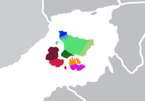
Greater Schoefengen Lesser Schoefengen Vasteland Ignahaven Schiereiland Noordeschausce Zuideschausce Dausken Claufen
|
General Geography
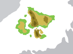
Abersiania is quite a flat nation, having a highest point of a mere 801m, at Mt Claufen in the south. This ridge runs along the nation, through the mainland, however is only distinguished as a small and low set of hills, averaging around 400m. Biomes like temperate forest and grassland are abundant, making up 68% of the nation. This provides an excellent environment for livestock and crop farming. The nations pride is its beaches, where tourism thrives, and all of Abersiania's big cities are situated. The abundance of coastline means that industries like seafood and salt production and the extraction of valuable minerals like gold, tin, titanium, and even rarely diamonds from the sedimentary rocks near the coast and riverbanks are doing extremely well. The positioning of the islands also make them a very good trading port, with unparalleled access to the Andaluzian Ocean.
Tourism in Abersiania
The main tourist attractions in Abersiania are the beaches. Making up 59% of Abersiania's coastline are sandy beaches. Alone, these bring in a combined average of ₵77 billion a year, making it the second largest industry in Abersiania, after seafood production. Popular tourist locations include smaller towns like Ingvangen and Zandesk, and the major cities, like Schausce, Schoefengen and Maufen.
Topography and Speleology of Abersiania
Abersiania's topography is not the most diverse, with a range of approximately -26m to 801m, making the country rather uneventful in the terms of dramatic mountains. However, the hardened volcanic rock the island is formed from means that rock formations can become rather dramatic, even if they are not particularly high. This is evident in places such as Ingvangen Falls, where the waterfalls have received a lot of exposure on social media. With sedimentary rock like limestone abundant in the southern regions, cave systems are not uncommon, and the biggest can stretch for miles. The most widely known are the Tauben Cave System, where the first signs of Abersianian civilisation was found, painted on the walls.

|
0m-299m 300m-499m 500m-699m 700m+
|
Distribution of Cultures in Abersiania
Wildlife of Abersiania
Land-dwelling Species
Aquatic Species
Armed Forces of Abersiania
Military Budgeting
Abersiania spends around 2.7% of its GDP annually on military, which is approximately ₵25 Billion. This is then split into the 4 branches of the military, Airforce, Land, Navy and Special Forces. As a percentage, around 50% goes towards the Airforce, 25% towards the Navy, 20% towards the Special Forces, and 5% towards the Army.
Airforce
The Abersianian Air Force was established in 1951, after it branched off of the Navy as aircraft became more prominent in the military scene. Today, the airforce is the most developed part of the military, operating nearly 600 aircraft, and 120,000 personnel. It makes up 50% of Abersiania's annual military budget, around ₵12.5 Billion. It saw extensive use in the Aberso-Illyrian War, where it was vital in the strategic strikes conducted against New Illyricum's Navy and maintaining air superiority over the battle field.
Army
The Abersianian Army is comparatively very small compared to the other branches of the military, as it is primarily used to defend mainland Abersiania, foriegn operations being conducted almost entirely by the Special Forces. For this reason it is largely made up of reserves, people who are not actively trained, but receive a course when they sign up, and monthly check-ups on physical ability, skills, etc.


