Difference between revisions of "San Miguel, San Miguel"
m (Text replacement - "Creeperian Spanish" to "Creeperian") |
|||
| Line 71: | Line 71: | ||
}} | }} | ||
| − | '''San Miguel''', officially the '''Municipality of San Miguel and Santo Domingo''' ([[Creeperian language|Creeperian]] – [[Creeperian script|Creeperian]]: Մփնիծիպիո դե Սան Միգփել յ Սանտո Դոմինգո; Creeperian – [[Iberic script|Iberic]]: ''Municipio de San Miguel y Santo Domingo''), is a city in [[Creeperopolis]] and the capital city of the [[Departments of Creeperopolis|department]] of [[San Miguel (department)|the same name]]. San Miguel is the largest non-coastal city in the [[ | + | '''San Miguel''', officially the '''Municipality of San Miguel and Santo Domingo''' ([[Creeperian language|Creeperian]] – [[Creeperian script|Creeperian]]: Մփնիծիպիո դե Սան Միգփել յ Սանտո Դոմինգո; Creeperian – [[Iberic script|Iberic]]: ''Municipio de San Miguel y Santo Domingo''), is a city in [[Creeperopolis]] and the capital city of the [[Departments of Creeperopolis|department]] of [[San Miguel (department)|the same name]]. San Miguel is the largest non-coastal city in the [[Xichútepa rainforest]] with a population of 1,202,538 as of 2022; almost 40 percent of all residents in the department live in its capital city. |
San Miguel is located at the meeting point of the [[San Miguel River]] and the [[Rísa River]]. The closest major city to San Miguel is [[Masario]], located approximately 50 miles to the south; the two cities are connected by the [[Yungas Road]], considered to be one of the most dangerous roads in the country, however, the Creeperian government is currently constructing [[Creeperian Imperial Highway 59|Imperial Highway 59]] to connect both San Miguel and Masario to the cities of [[Santiago Texacuangos]] and [[La'Unión, La'Unión|La'Unión]] in the department of [[La'Unión (department)|La'Unión]] and is expected to be complete by 2030. Due to the lack of substantial ground-based infrastructure, transportation to and from San Miguel is mostly handled by the [[Cruzadore San Miguel International Airport]] and the [[Santo Domingo de la'Jungla Riverport]]. | San Miguel is located at the meeting point of the [[San Miguel River]] and the [[Rísa River]]. The closest major city to San Miguel is [[Masario]], located approximately 50 miles to the south; the two cities are connected by the [[Yungas Road]], considered to be one of the most dangerous roads in the country, however, the Creeperian government is currently constructing [[Creeperian Imperial Highway 59|Imperial Highway 59]] to connect both San Miguel and Masario to the cities of [[Santiago Texacuangos]] and [[La'Unión, La'Unión|La'Unión]] in the department of [[La'Unión (department)|La'Unión]] and is expected to be complete by 2030. Due to the lack of substantial ground-based infrastructure, transportation to and from San Miguel is mostly handled by the [[Cruzadore San Miguel International Airport]] and the [[Santo Domingo de la'Jungla Riverport]]. | ||
Latest revision as of 04:58, 1 April 2024
San Miguel Մփնիծիպիո դե Սան Միգփել յ Սանտո Դոմինգո | |
|---|---|
Departmental capital | |
| Municipality of San Miguel and Santo Domingo | |
 The skyline of central San Miguel | |
| Motto(s): Ծորազօն դե լա'Ջփնգլա Corazón de la'Jungla (Heart of the Jungle) | |
| Coordinates: 30.03°S 57.17°W | |
| Country | |
| Department | |
| Founded | 9 March 1360 |
| Founded by | Miguel I |
| Named for | Miguel I and Saint Domingo |
| Government | |
| • Type | Viceroyalty |
| • Viceroy | Felipe Durán Parejas |
| Population (2022) | |
| • Total | 1,202,538 |
| Demonym(s) | San Migueleño |
| Time zone | AMT–4 (TSS) |
| Website | www.sanmiguel.gob.cr |
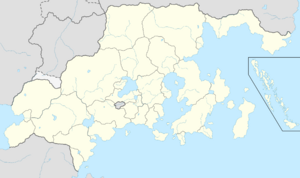
San Miguel, officially the Municipality of San Miguel and Santo Domingo (Creeperian – Creeperian: Մփնիծիպիո դե Սան Միգփել յ Սանտո Դոմինգո; Creeperian – Iberic: Municipio de San Miguel y Santo Domingo), is a city in Creeperopolis and the capital city of the department of the same name. San Miguel is the largest non-coastal city in the Xichútepa rainforest with a population of 1,202,538 as of 2022; almost 40 percent of all residents in the department live in its capital city.
San Miguel is located at the meeting point of the San Miguel River and the Rísa River. The closest major city to San Miguel is Masario, located approximately 50 miles to the south; the two cities are connected by the Yungas Road, considered to be one of the most dangerous roads in the country, however, the Creeperian government is currently constructing Imperial Highway 59 to connect both San Miguel and Masario to the cities of Santiago Texacuangos and La'Unión in the department of La'Unión and is expected to be complete by 2030. Due to the lack of substantial ground-based infrastructure, transportation to and from San Miguel is mostly handled by the Cruzadore San Miguel International Airport and the Santo Domingo de la'Jungla Riverport.


