Difference between revisions of "Nationway 11"
Jump to navigation
Jump to search
| Line 1: | Line 1: | ||
{{Infobox road | {{Infobox road | ||
| − | | | + | | name = Riksväg 11 |
| − | | | + | | translation = Nationway 11 |
| − | + | | marker_image = [[Image:Vänster_-_blå.svg|500x34px]][[Image:1_-_blå.svg|500x34px]][[Image:1_-_blå.svg|500x34px]][[Image:Höger_-_blå.svg|500x34px]] | |
| − | | marker_image = [[ | ||
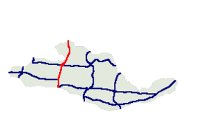
| map = svedonia_roadnet_N11.png | | map = svedonia_roadnet_N11.png | ||
| map_alt = Map of Svedonia, N11 marked | | map_alt = Map of Svedonia, N11 marked | ||
| Line 20: | Line 19: | ||
| next_route = | | next_route = | ||
}} | }} | ||
| + | |||
| + | [[Image:Vänster_-_blå.svg|500x34px]][[Image:1_-_blå.svg|500x34px]][[Image:1_-_blå.svg|500x34px]][[Image:Höger_-_blå.svg|500x34px]] | ||
| + | '''[[Nationway]] 11''' (Svedonian: ''Riksväg 11'') is a road in Svedonia that connects [[Freista]] and [[Nyfront]] to the Svedonian Nationway system. | ||
