Difference between revisions of "Administrative divisions of Terranihil"
Terranihil (talk | contribs) |
Terranihil (talk | contribs) |
||
| Line 25: | Line 25: | ||
! # !! [[Flag of Terranihil#Departmental Flags|Emblem]] !! Governorate !! Capital !! Largest City !! Population<br>(2021) | ! # !! [[Flag of Terranihil#Departmental Flags|Emblem]] !! Governorate !! Capital !! Largest City !! Population<br>(2021) | ||
|- | |- | ||
| − | | 1 || [[File:Gov emblem 4.png|60px]] || [[Minaltar (governorate)|Minaltar]] || [[Minaltar]] || [[Minaltar]] || | + | | 1 || [[File:Gov emblem 4.png|60px]] || [[Minaltar (governorate)|Minaltar]] || [[Minaltar]] || [[Minaltar]] || 20,340,000 |
|- | |- | ||
| − | | 2 || [[File:Gov emblem 9.png|60px]] || [[Felsafella]] || [[Hervanav]]<!--land of nav--> || [[Araz]] || | + | | 2 || [[File:Gov emblem 9.png|60px]] || [[Felsafella]] || [[Hervanav]]<!--land of nav--> || [[Araz]] || 9,420,000 |
|- | |- | ||
| − | | 3 || [[File:Gov emb 8.png|60px]] || [[Čerasa]] || [[Bassel]] || [[Softemla]]<!--from onion in arabic--> || | + | | 3 || [[File:Gov emb 8.png|60px]] || [[Čerasa]] || [[Bassel]] || [[Softemla]]<!--from onion in arabic--> || 7,500,000 |
|- | |- | ||
| − | | 4 || [[File:Gov emblem 10.png|60px]] || [[Mažel Maplas]] || [[Scipia]] || [[Scipia]] || | + | | 4 || [[File:Gov emblem 10.png|60px]] || [[Mažel Maplas]] || [[Scipia]] || [[Scipia]] || 6,364,000 |
|- | |- | ||
| − | | 5 || [[File:Gov emblem 6.png|60px]] || [[Dastivia (governorate)|Dastivia]] || [[Dastivus]] || [[Dastivus]] || 7, | + | | 5 || [[File:Gov emblem 6.png|60px]] || [[Dastivia (governorate)|Dastivia]] || [[Dastivus]] || [[Dastivus]] || 7,800,0000 |
|- | |- | ||
| − | | 6 || [[File:Gov emb 1.png|60px]] || [[Upa]] || [[Pinaria]] || [[Pinaria]] || | + | | 6 || [[File:Gov emb 1.png|60px]] || [[Upa]] || [[Pinaria]] || [[Pinaria]] || 7,770,000 |
|- | |- | ||
| − | | 7 || [[File:Gov emblem 11.png|60px]] || [[West Acillia]] || [[Faıṭarp]]<!--faıṭ harp first grass--> || [[Faıṭarp]] || | + | | 7 || [[File:Gov emblem 11.png|60px]] || [[West Acillia]] || [[Faıṭarp]]<!--faıṭ harp first grass--> || [[Faıṭarp]] || 4,710,000 |
|- | |- | ||
| − | | 8 || [[File:Gov emblem 12.png|60px]] || [[East Acillia]] || [[Čečepšjo]]<!-- čeči (tsheytshee) psižo meaning new psydo--> || [[Čečepšjo]] || | + | | 8 || [[File:Gov emblem 12.png|60px]] || [[East Acillia]] || [[Čečepšjo]]<!-- čeči (tsheytshee) psižo meaning new psydo--> || [[Čečepšjo]] || 6,890,000 |
|- | |- | ||
| − | | 9 || [[File:Gov emb 2.png|60px]] || [[Malgax]] || [[Mestaga]] || [[Mestaga]] || | + | | 9 || [[File:Gov emb 2.png|60px]] || [[Malgax]] || [[Mestaga]] || [[Mestaga]] || 6,530,000 <!--2 urb--> |
|- | |- | ||
| − | | 10 || [[File:Valeriana emblem.png|60px]] || [[Neclemun]]<!--from neklmuon NeKHLMuON meaning dream--> || [[Sainte-Delphine]] || [[Sainte-Delphine]] || | + | | 10 || [[File:Valeriana emblem.png|60px]] || [[Neclemun]]<!--from neklmuon NeKHLMuON meaning dream--> || [[Sainte-Delphine]] || [[Sainte-Delphine]] || 5,560,000 <!--2 urb--> |
|- | |- | ||
| − | | 11 || [[File:Gov emblem 5.png|60px]] || [[Sipaipa (governorate)|Sipaipa]] || [[Sipaipa]] || [[Sipaipa]] || | + | | 11 || [[File:Gov emblem 5.png|60px]] || [[Sipaipa (governorate)|Sipaipa]] || [[Sipaipa]] || [[Sipaipa]] || 7,660,000 <!--3 urb--> |
|- | |- | ||
| − | | 12 || [[File:Govv emblem 3.png|60px]] || [[Pytabia (governorate)|Pytabia]] || [[Valeriana]]<!--from arabic khadra for green--> || [[Valeriana]] || | + | | 12 || [[File:Govv emblem 3.png|60px]] || [[Pytabia (governorate)|Pytabia]] || [[Valeriana]]<!--from arabic khadra for green--> || [[Valeriana]] || 9,980,000 <!--5 for urb --> |
|- | |- | ||
| - || [[File:Coat of arms terra FINAL.png|60px]] || [[Terranihil]] || [[Minaltar]] || [[Minaltar]] || 55,000,000 | | - || [[File:Coat of arms terra FINAL.png|60px]] || [[Terranihil]] || [[Minaltar]] || [[Minaltar]] || 55,000,000 | ||
Revision as of 19:30, 25 June 2022
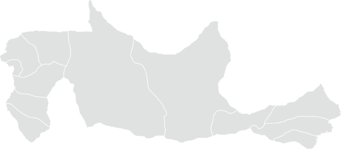
Terranihil is made up of 12 governorates, each of which is composed of 5 districts for a total of 60 districts. Each district then contains a varying number of counties for a total of 356. Terranihil is a unitary state, thus political power is centered within the national government, with limited autonomy granted to local administrations. A governor and governatorial assembly manages each governorate, a district-minister and district assembly manage each district, and counties generally have elected councils.
Contents
History
Governorates
Each of the twelve governorates has an elected governatorial assembly. The number of seats on the assembly and election method varies but it is similar to the ranked process in which the parliament is elected. The assembly then elects a governor, also called governor-minister, as its executive leader.
| # | Emblem | Governorate | Capital | Largest City | Population (2021) |
|---|---|---|---|---|---|
| 1 |  |
Minaltar | Minaltar | Minaltar | 20,340,000 |
| 2 |  |
Felsafella | Hervanav | Araz | 9,420,000 |
| 3 |  |
Čerasa | Bassel | Softemla | 7,500,000 |
| 4 |  |
Mažel Maplas | Scipia | Scipia | 6,364,000 |
| 5 |  |
Dastivia | Dastivus | Dastivus | 7,800,0000 |
| 6 |  |
Upa | Pinaria | Pinaria | 7,770,000 |
| 7 |  |
West Acillia | Faıṭarp | Faıṭarp | 4,710,000 |
| 8 |  |
East Acillia | Čečepšjo | Čečepšjo | 6,890,000 |
| 9 |  |
Malgax | Mestaga | Mestaga | 6,530,000 |
| 10 |  |
Neclemun | Sainte-Delphine | Sainte-Delphine | 5,560,000 |
| 11 |  |
Sipaipa | Sipaipa | Sipaipa | 7,660,000 |
| 12 |  |
Pytabia | Valeriana | Valeriana | 9,980,000 |
| - |  |
Terranihil | Minaltar | Minaltar | 55,000,000 |
