Difference between revisions of "Patern"
Jump to navigation
Jump to search
(Created page with "{{Infobox mountain | name = Patern | photo = Paternkofel.jpg | photo_caption = | elevation_m = 3744 | elevation_ref = | prominence = | map = | map_caption = | label_posit...") |
|||
| Line 6: | Line 6: | ||
| elevation_ref = | | elevation_ref = | ||
| prominence = | | prominence = | ||
| − | | map = | + | | map = Tirol |
| − | | map_caption = | + | | map_caption = Tirol |
| label_position = | | label_position = | ||
| listing = | | listing = | ||
Revision as of 12:50, 13 April 2021
| Patern | |
|---|---|
 | |
| Highest point | |
| Elevation | 3,744 m (12,283 ft) |
| Coordinates | 9.9°W 50.0°N |
| Geography | |
Lua error in Module:Location_map at line 399: Malformed coordinates value.
| |
| Location | Provinzia Adesc |
| Country | |
| Parent range | Dolomita |
| Climbing | |
| First ascent | 11 September 1882 by Franz Innerkofler |
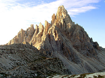
The Patern is a mountain in the Dolomita on the border between Provinzia Adesc and the Provinzia Inn, Tirol.


