Difference between revisions of "Nantelòu"
Jump to navigation
Jump to search
m (Categories) |
|||
| Line 6: | Line 6: | ||
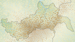
| map_caption = Tirol | | map_caption = Tirol | ||
| mapsize = | | mapsize = | ||
| − | | coordinates = | + | | coordinates = 51.4340°N 8.8536°W |
| elevation_m = 7118.51 | | elevation_m = 7118.51 | ||
| elevation_ref = | | elevation_ref = | ||
| Line 18: | Line 18: | ||
}} | }} | ||
| − | '''Nantelòu''' is the highest mountain in the eastern [[Provinzia Passeier|Passeier]] [[Dolomita Mountain Range|Dolomita]] in northeastern [[Tirol]], | + | '''Nantelòu''' is the highest mountain in the eastern [[Provinzia Passeier|Passeier]] [[Dolomita Mountain Range|Dolomita]] in northeastern [[Tirol]], south of the town of [[Hoistoda]]. Nantelòu is an ultra-prominent peak. |
[[Category:Tirol]][[Category:Terraconserva]][[Category:Mountains of Terraconserva]] | [[Category:Tirol]][[Category:Terraconserva]][[Category:Mountains of Terraconserva]] | ||
Latest revision as of 17:52, 4 May 2022
| Nantelòu | |
|---|---|
 | |
| Highest point | |
| Elevation | 7,118.51 m (23,354.7 ft) |
| Prominence | 4,611 m (15,128 ft) |
| Coordinates | 51.4340°N 8.8536°W |
| Geography | |
| Location | |
| Parent range | Dolomita |
| Climbing | |
| First ascent | 18 September 1863 by Paul Grohmann, F. Lacedelli, A. Lacedelli, and Matteo Ossi |
| Easiest route | Exposed scramble |
Nantelòu is the highest mountain in the eastern Passeier Dolomita in northeastern Tirol, south of the town of Hoistoda. Nantelòu is an ultra-prominent peak.
