Bird Islands
Bird Islands Fuglaeyjar | |
|---|---|
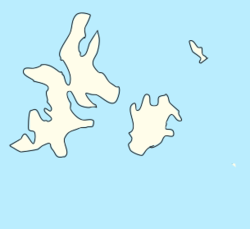
 Map of the islands | |
| Country | |
| Capital | Landeyjar |
| Area | |
| • Reykani Overseas Territory | 55.87 km2 (21.57 sq mi) |
| • Water | negligible km2 (Formatting error: invalid input when rounding sq mi) |
| • Urban | 2 km2 (0.8 sq mi) |
| Elevation | 67 m (220 ft) |
| Population | |
| • Reykani Overseas Territory | 342 |
| • Density | 6.1/km2 (16/sq mi) |
| Demonym(s) | Bird Islandian |
Bird Islands(Reykani:Fuglaeyjar) is a Overseas Territory of Reykanes. Officially known as the Municipality of Bird Islands. It is located in the Northern parts of Alathlasiu Ocean. It consists of one Main island and two uninhabited islands. Only the Biggest island has a number of people present on it. Reykani is the official language and the Reykanesi Fjord is the main currency used here. Most Services aren't available other than a small fire department and a small clinic. The islands have no native animal population other than the notable population of birds.
Contents
Etymology
The term "Bird Islands" was given by the explorer Eggert Ólafsson after the massive amounts of Birds that migrate through and nest on the islands. Some rare bird species can be found here as well which some of them are native to the islands.
History
Formation of the islands
First human settlement
Before the early 1200s there was no human presence on the islands.
Geography
Topography
Climate
| Climate data for Landeyjar, 1925–2005 averages | |||||||||||||
|---|---|---|---|---|---|---|---|---|---|---|---|---|---|
| Month | Jan | Feb | Mar | Apr | May | Jun | Jul | Aug | Sep | Oct | Nov | Dec | Year |
| Record high °C (°F) | 15.1 (59.2) |
15.0 (59.0) |
18.5 (65.3) |
20.8 (69.4) |
23.6 (74.5) |
26.1 (79.0) |
27.8 (82.0) |
26.8 (80.2) |
26.3 (79.3) |
24.0 (75.2) |
20.9 (69.6) |
15.3 (59.5) |
27.8 (82.0) |
| Average high °C (°F) | 9.9 (49.8) |
10.0 (50.0) |
10.9 (51.6) |
12.6 (54.7) |
14.7 (58.5) |
17.3 (63.1) |
19.3 (66.7) |
19.7 (67.5) |
18.3 (64.9) |
15.0 (59.0) |
12.2 (54.0) |
10.6 (51.1) |
14.2 (57.6) |
| Daily mean °C (°F) | 8.2 (46.8) |
8.2 (46.8) |
8.8 (47.8) |
10.1 (50.2) |
12.1 (53.8) |
14.7 (58.5) |
16.6 (61.9) |
17.0 (62.6) |
15.7 (60.3) |
12.9 (55.2) |
10.5 (50.9) |
8.9 (48.0) |
12.0 (53.6) |
| Average low °C (°F) | 6.4 (43.5) |
6.3 (43.3) |
6.7 (44.1) |
7.5 (45.5) |
9.5 (49.1) |
12.0 (53.6) |
13.8 (56.8) |
14.3 (57.7) |
13.1 (55.6) |
10.8 (51.4) |
8.7 (47.7) |
7.1 (44.8) |
9.7 (49.4) |
| Record low °C (°F) | −7.2 (19.0) |
−4.3 (24.3) |
−1.6 (29.1) |
−0.4 (31.3) |
3.5 (38.3) |
6.8 (44.2) |
9.7 (49.5) |
8.6 (47.5) |
8.4 (47.1) |
5.5 (41.9) |
2.3 (36.1) |
−0.8 (30.6) |
−7.2 (19.0) |
| Average precipitation mm (inches) | 93.2 (3.67) |
75.6 (2.98) |
57.4 (2.26) |
49.6 (1.95) |
47.6 (1.87) |
50.4 (1.98) |
68.5 (2.70) |
76.8 (3.02) |
71.1 (2.80) |
89.0 (3.50) |
100.0 (3.94) |
100.1 (3.94) |
879.3 (34.61) |
| Average precipitation days | 15.1 | 13.3 | 11.7 | 10.3 | 8.6 | 8.7 | 8.8 | 10.3 | 9.6 | 13.8 | 15.6 | 15.9 | 141.7 |
| Average relative humidity (%) (daily average) | 82 | 81 | 83 | 85 | 86 | 86 | 86 | 85 | 86 | 85 | 82 | 81 | 84 |
| Average dew point °C (°F) | 6 (43) |
5 (41) |
6 (43) |
7 (45) |
10 (50) |
12 (54) |
14 (57) |
14 (57) |
13 (55) |
11 (52) |
8 (46) |
6 (43) |
9 (49) |
| Mean monthly sunshine hours | 58.3 | 83.4 | 131.6 | 195.2 | 220.6 | 211.0 | 205.0 | 196.6 | 165.1 | 116.9 | 72.1 | 52.1 | 1,707.9 |
| Source: Trust me bro | |||||||||||||

