Difference between revisions of "Bou Regreg River"
| Line 6: | Line 6: | ||
| image_alt = | | image_alt = | ||
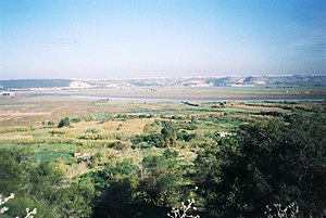
| image_caption = Valley of the Bou Regreg near [[Majorca]], [[Majocco]] | | image_caption = Valley of the Bou Regreg near [[Majorca]], [[Majocco]] | ||
| − | | map = | + | | map = [[File:Screenshot 2024-08-16 144508.png|300px]] |
| − | | map_size = | + | | map_size = |
| map_alt = | | map_alt = | ||
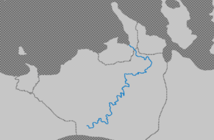
| map_caption = Course of the Bou Regreg | | map_caption = Course of the Bou Regreg | ||
Latest revision as of 03:29, 16 August 2024
| Bou Regreg | |
|---|---|
 | |
 Course of the Bou Regreg | |
| Location | |
| Country | |
| Physical characteristics | |
| Mouth | |
• location | Tarqiqini Lakes |
| Length | 280 km (170 mi) |
The Bou Regreg (أبو رقراق) is a river located in the capital city of Majocco, Majorca. which discharges into the Tarqiqini Lakes between the cities of Majorca and Nfifkhi. The estuary of this river is termed Wadi Majurki.
The river is 280 kilometres long, with a tidal estuary of approximately 24 kilometres extending upriver. Its average discharge is 23 m3/s and can reach 1500 m3/s during periods of flooding. The source of the river originates from the Jabaliat mountains at an altitude of 1712 meters on the level of Ajbel Wasidi (province of Majorca Minor) and of Grou (province of Florin D'eau) and descends to its mouth at the Tarqiqini Lakes.
Water quality
Water issues of the Bou Regreg include tidal intrusion, excessive runoff of nitrates from agricultural land uses and mercury contamination thought to arise from use of certain pesticides within the drainage basin.