Hafnir
Hafnir | |
|---|---|
Capital (legislative) | |
 | |
 Flag | |
 | |
| Municipality | Hafnir Special Autonomous municipality |
| Area | |
| • Total | 283 km2 (109 sq mi) |
| • Water | 2 km2 (0.8 sq mi) |
| Population (2020) | |
| • Total | 387,456 |
| • Density | 1,400/km2 (3,500/sq mi) |
| Demonym(s) | Reykan |
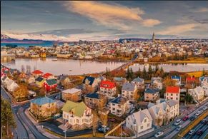
Hafnir is the Capital and largest city of Reykanes. Located in South West Reykanes on the Vifilsstadavatn river . It lies on the Rifstangi peninsula between the sea and the Kjolur mountain range but it is not a coastal city even if its greater area extends to the coast. Hafnir is one of Reykanes's two capital cities. Serving as the seat of the legislative branch of the government, and as the host to all foreign embassies to Reykanes. Judicial system is also done here. It is the most Northern and the only city in Reykanes over 300,000 population making it the smallest capital city in the World. It is a major economical and cultural center in Reykanes for being the only capitol for centuries. The Parliament of Reykanes is contained within the city's metropolitan area. The city has a subpolar oceanic climate.
Hafnir was established in 114 BC as a City state until it was integrated in to the Kingdom of Reykanes. It takes its name from two large 2nd century farms Sandhöfn and Kirkjuhöfn which are museums today.
Contents
Etymology
The word Hafnir means harbor or port.
History
Administration
Geography
Demography
Transport in Hafnir
Hafnir is the biggest transport hub in the country. It has a developed transport network. The local transport services are controlled by the local government such as the Hafnir Metro, Buses but the rail services are controlled by the TEJ like the suburban railways and trams. It also hosts one of the international airports, which is the biggest and main airport in Reykanes. Long-distance rail lines connect Hafnir with all of the major cities of Reykanes and with the most rural areas in the country.
Public transport users can use basic tickets or the contactless card known as Samgöngupassi (Transit Pass) and the mobile version of the Samgöngupassi, which today is the most popular, it also notifies the user of any delay or news of the public transportation.
| System | Stations / Lines / Net length | Annual ridership |
|---|---|---|
| Hafnir Suburban Rail | TBD / TBD / [convert: invalid number] | TBD (2016) |
| Hafnir Metro | 8 / 1 / 9.8 km (6.1 mi) | 26,827,500 (2017) |
| Hafnir Trams | TBD / TBD / [convert: invalid number] | TBD (2017) |
| Hafnir Buses | TBD / 16 / [convert: invalid number] | TBD (2017) |
Travelers can access all modes of transport with a single ticket.
Road
Per capita car ownership in Reykanes is roughly 633 vehicles per 1,000, though Hafnir is not severely affected by congestion, however the local government makes the effort to lower the numbers, established multiple car free zones and promoting the use of electric cars, , as 23% of all registered cars in the municipality are fully electric. Most major multi lane roads run through downtown and the most populated areas. The two major motorways in Reykanes, Þjóðvegur 1 and Þjóðvegur 2 connect in Hafnir.
Aviation
Cycling
Rail
Hafnir Metro
railways
Bus
Bus transport in Hafnir is the biggest public transportation in the city with 200 buses in their fleet.
Education
Culture
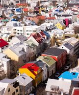
Gallery of Hafnir
- Gallery
Vifilsstadavatn river in Hafnir.

The HQ of Reykani Oil known as the ROL Turn. It is the highest building in Reykanes,being 96 meters.


| Rank | Municipalities | Pop. | |||||||
|---|---|---|---|---|---|---|---|---|---|
Hafnir |
1 | Hafnir | Hafnir | 387,456 | |||||
| 2 | Cape Nátfari | Cape Nátfari | 80,157 | ||||||
| 3 | Laugleós | Norðurhöfði | 51,907 | ||||||
| 4 | kaupmannahöfn | Vesturhöfði | 49,291 | ||||||
| 5 | Port Sturla | Natal | 41,082 | ||||||
| 6 | Höfn | Kvuarry | 40,748 | ||||||
| 7 | fálki | Vesturhöfði | 38,108 | ||||||
| 8 | Ingólfr | Skutustadhir | 35,028 | ||||||
| 9 | Vallanes | Borgarfjörður | 33,684 | ||||||
| 10 | Nýjasavotta | Faxaflói | 30,273 | ||||||